|
|
| Mesoscale Discussion 1312 | |
| < Previous MD | |

|
|
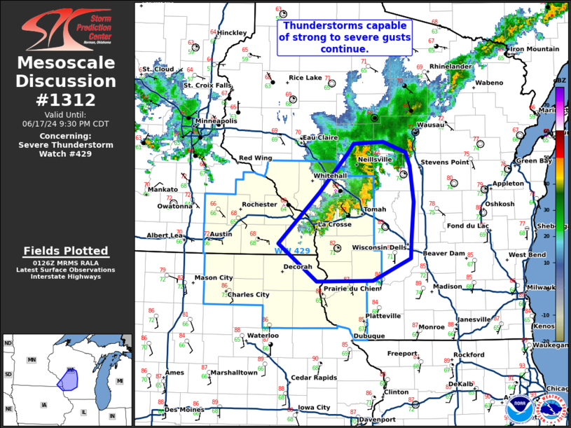
Mesoscale Discussion 1312 NWS Storm Prediction Center Norman OK 0829 PM CDT Mon Jun 17 2024 Areas affected...west-central Wisconsin Concerning...Severe Thunderstorm Watch 429... Valid 180129Z - 180230Z The severe weather threat for Severe Thunderstorm Watch 429 continues. SUMMARY...Thunderstorms capable of instances of strong to severe wind will continue eastward this evening. DISCUSSION...A line of thunderstorms ongoing from central WI into far southeastern MN and northeastern IA will continue to pose some risk of strong to severe wind. Confidence in downstream risk beyond WW429 remains uncertain. The downstream environment is moist and unstable, with dewpoints in the mid 70s and MLCAPE around 2000 J/kg. Should storms be able to develop a strong cold pool and become better organized within this regime, the risk for damaging wind may continue past WW429. Thus far, this line has remained sub-severe, with strongest reflectivity located mostly well behind its own outflow, but trends will be monitored. A downstream watch is unlikely at this time. ..Thornton/Edwards.. 06/18/2024 ...Please see www.spc.noaa.gov for graphic product... ATTN...WFO...GRB...MKX...ARX... LAT...LON 43629184 44229118 44679074 44799063 44829015 44708980 44548973 44128967 43668971 43468972 43199032 43199122 43629184 |
|
|
Top/All Mesoscale Discussions/Forecast Products/Home |
|