An area of disturbed weather over the southern Gulf of Mexico’s Bay of Campeche, designated Invest 91L by the National Hurricane Center, or NHC, on Monday morning, will likely organize into the season’s first tropical depression by Wednesday as it moves west to west-northwest at less than 10 mph toward the northeastern Mexican coast. A hurricane hunter aircraft is scheduled to investigate the system on Monday afternoon.
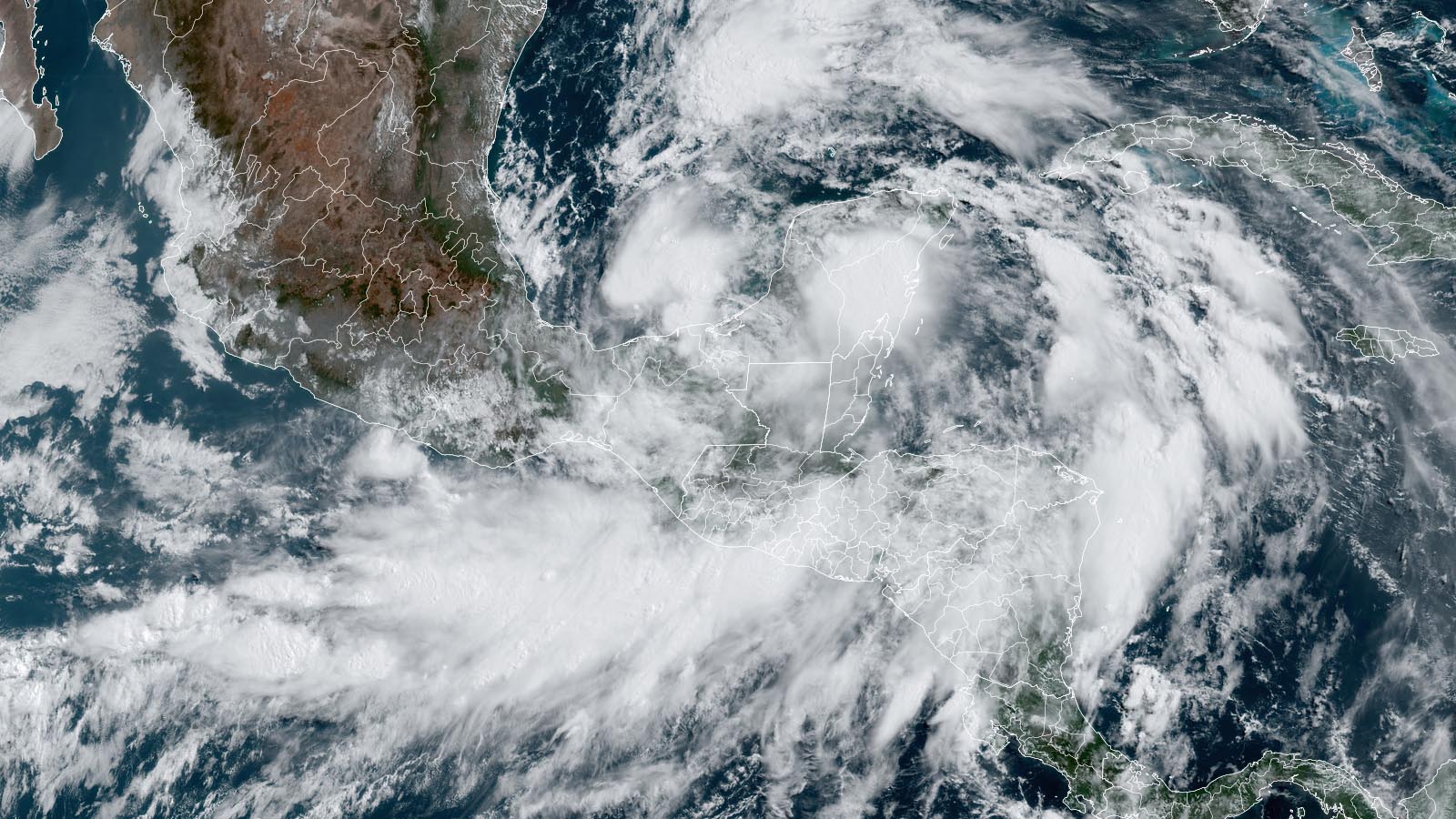
Satellite images on Monday morning showed 91L as a broad area of rotation centered over Mexico’s Yucatán Peninsula, with a possible circulation center attempting to develop near the coast of the Bay of Campeche. Heavy thunderstorm activity was clumpy and scattered but was beginning to grow more organized.
Conditions in the southern Gulf of Mexico were quite favorable for development. Sea surface temperatures were near record-warm, about 30 degrees Celsius (86°F), wind shear was a moderate 10-15 knots, and the atmosphere was very moist, with a midlevel relative humidity of 75-80%. The sprawling nature of the system will initially keep development slow to occur, but the topography of the surrounding coast can help get 91L spinning.

Forecast for 91L
The GFS and European model ensembles remain in strong agreement that 91L will develop into a tropical depression or tropical storm over the southern Gulf of Mexico’s Bay of Campeche by Wednesday, then move onto the coast of northeast Mexico a few hundred miles south of the Texas border by Wednesday night. Increasing wind shear and a short time over water will likely prevent much intensification, but the system has favorable enough conditions to become Tropical Storm Alberto before landfall. Regardless of development, 91L will bring heavy rains in excess of four inches to a large swath of coasts of Mexico and Texas through Thursday. Lesser rains of one to four inches are likely for the Louisiana coast.
In its 8 a.m. EDT Monday Tropical Weather Outlook, the National Hurricane Center gave 91L two-day and seven-day odds of development of 70%. The average date of the arrival of the Atlantic’s first named storm is June 20.

Southern Texas could greatly use the rain. As documented by Michael Lowry in his latest Substack post, two of the key reservoirs supplying water to the area are very low. Falcon Reservoir on the Rio Grande is less than 10% full — some of the lowest levels in 20 years — while Medina Lake in the Texas Hill Country, an important source for local irrigation, dropped to less than 3% capacity. On the other hand, the rains may be problematic for portions of the Houston-Galveston area, which has seen as much as 600% of its normal May rainfall (Fig. 2).
Life-threatening rains inundating the Pacific coast of Central America and southeastern Mexico
The 91L disturbance is part of a larger area of disturbed weather called a Central American Gyre spinning over Central America. The gyre — a type of monsoon low — is a weak but expansive area of surface low pressure that can persist for two weeks or more across Central America and adjacent parts of the Atlantic and Pacific, including the western Caribbean and southwest Gulf of Mexico. They are most common in May, June, September, October, and November. The gyres often spin off smaller circulations that can become full-fledged tropical cyclones. One such circulation formed near the Pacific coast of southern Mexico on Sunday, and was designated Invest 90E by NHC. However, this circulation has since moved inland and is now being given a 0% chance of development (Fig. 1).

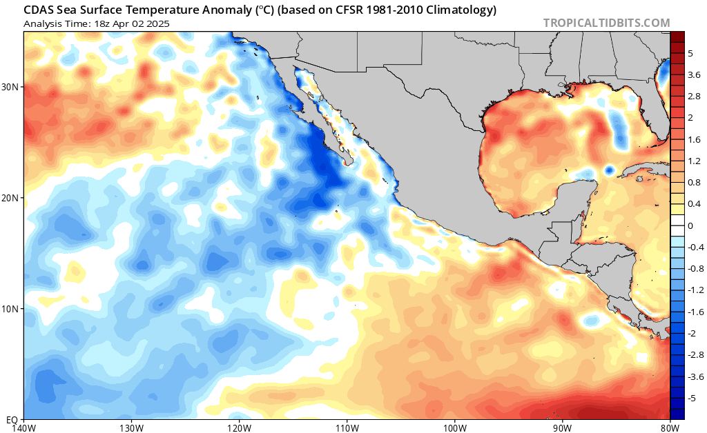
Over the coming week, the counterclockwise flow of air around the Central American Gyre will pull copious moisture over Central America and southeastern Mexico from portions of the Eastern Pacific where water temperatures are about 1 degree Celsius (1.8°F) above average. Most of Central America and Mexico experienced their hottest spring (March-May) on record, heating the surrounding waters to record levels. These record-warm waters will be able to supply a record amount of moisture to the atmosphere. This moisture-laden air will be forced upward by the high terrain along the coast, resulting in torrential rains along the Pacific coasts of El Salvador, Guatemala, and southern Mexico.
Two locations in El Salvador, Finca Los Andes and Los Naranjos, recorded over 10 inches (254 mm) of rain in 24 hours on Sunday; portions of the coast of Guatemala received over 160 mm (6.3 inches). Additional rains in excess of 10 inches (254 mm) are predicted for this region over the next five days (Fig. 3).
A tropical disturbance heading toward the Southeast could develop by late week
At the tail end of a decayed frontal zone, a weak disturbance several hundred miles north of Puerto Rico has the potential to develop by midweek as it drifts toward the southeast U.S. coast, potentially arriving on Thursday or Friday. This disturbance will be embedded in the circulation around a westward-moving upper low, which will inhibit the upper-level outflow needed for full-scale tropical development. However, sea surface temperatures along its path will be around 27-28 degrees Celsius (81-82 degrees Fahrenheit), about 0.5-1°C or 2°F warmer than average for mid-June and more than ample to support development.
As of early Monday, only a small number of European and GFS ensemble model members were developing this system and none were spawning an intense surface low, suggesting that any development will likely be muted. There’s also little support from climatology for a system from the Northwest Atlantic moving onto the Southeast U.S. coast in June. Still, a compact tropical depression or tropical storm approaching the Southeast U.S. late in the week can’t be ruled out. In its Tropical Weather Outlook issued at 8 a.m. EDT Monday, NHC gave this area a 10% chance of becoming at least a tropical depression in the next two days and a 30% chance over the next week. The next name on the 2024 Atlantic list after Alberto is Beryl.
We help millions of people understand climate change and what to do about it. Help us reach even more people like you.
Source link