|
|
| Mesoscale Discussion 1278 | |
| < Previous MD | |

|
|
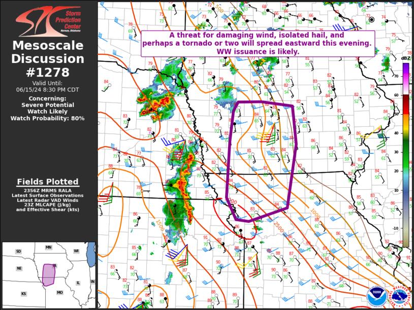
   Mesoscale Discussion 1278
   NWS Storm Prediction Center Norman OK
   0658 PM CDT Sat Jun 15 2024

   Areas affected...Northwest MO into western/central IA

   Concerning...Severe potential...Watch likely

   Valid 152358Z - 160130Z

   Probability of Watch Issuance...80 percent

   SUMMARY...A threat for damaging wind, isolated hail, and possibly a
   tornado or two will spread eastward this evening. Watch issuance is
   likely.

   DISCUSSION...A storm cluster is gradually increasing in size across
   northeast KS into southeast NE, as the northern portion of a smaller
   cluster that developed earlier over central KS begins to merge with
   ongoing storms across southeast NE. Moderate downstream buoyancy and
   marginally sufficient deep-layer shear will continue to support
   organized convection through the evening, and the ongoing storm
   cluster is expected to move into parts of northwest MO and
   southwest/central IA with time.

   With a linear mode already established, damaging winds may be the
   most likely hazard as storms progress east-northeastward this
   evening. However, rather strong low-level shear/SRH (as noted on
   regional VWPs) will also support potential for a tornado or two.
   Downstream watch issuance is likely between 7-8 PM CDT if trends
   continue to support a severe threat this evening into northwest MO
   and southwest/central IA.

   ..Dean/Smith.. 06/15/2024

   ...Please see www.spc.noaa.gov for graphic product...

   ATTN...WFO...DMX...EAX...OAX...

   LAT...LON   40059512 41299505 41989494 42189481 42199412 42099318
               41239308 39819337 39519448 39559484 40059512
|
|
|
Top/All Mesoscale Discussions/Forecast Products/Home |
|