|
|
| Mesoscale Discussion 1277 | |
| < Previous MD | |

|
|
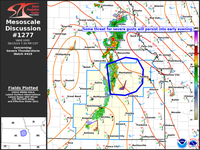
Mesoscale Discussion 1277 NWS Storm Prediction Center Norman OK 0605 PM CDT Sat Jun 15 2024 Areas affected...Parts of northeast KS Concerning...Severe Thunderstorm Watch 419... Valid 152305Z - 160030Z The severe weather threat for Severe Thunderstorm Watch 419 continues. SUMMARY...Some threat for severe gusts will persist into early evening. DISCUSSION...A small thunderstorm cluster with a history of producing severe gusts is moving across northeast KS. A shortwave trough moving across central KS is likely aiding this storm cluster, which will likely persist in some form through early evening. While there has been some tendency for outflow to outpace the leading edge of convection, some reintensification of this cluster will be possible as it moves into a downstream environment characterized by richer low-level moisture and MLCAPE in excess of 2500 J/kg. Given the current outflow-dominant cluster mode, severe gusts will likely continue to be the primary threat in the short term, though the downstream environment would also favor some potential for hail and possibly a tornado, if any more cellular development can occur along/ahead of the ongoing storms. ..Dean.. 06/15/2024 ...Please see www.spc.noaa.gov for graphic product... ATTN...WFO...EAX...TOP...ICT... LAT...LON 39519706 39759626 39689575 39339549 38879553 38619580 38489627 38519691 39519706 |
|
|
Top/All Mesoscale Discussions/Forecast Products/Home |
|