|
|
| Mesoscale Discussion 1242 | |
| < Previous MD Next MD > | |

|
|
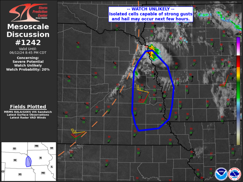
   Mesoscale Discussion 1242
   NWS Storm Prediction Center Norman OK
   0617 PM CDT Wed Jun 12 2024

   Areas affected...far eastern Nebraska into western Iowa

   Concerning...Severe potential...Watch unlikely

   Valid 122317Z - 130145Z

   Probability of Watch Issuance...20 percent

   SUMMARY...Isolated cells may produce locally damaging gusts and
   hail.

   DISCUSSION...Strong heating has led to an uncapped air mass near a
   surface trough extending from eastern NE into northwest KS. Visible
   imagery and radar indicate storms beginning to form near SUX, with
   additional towering Cu into NE along the boundary.

   Convergence near this boundary and the uncapped air mass where mid
   90s F have been achieved may support isolated severe storms over the
   next 1-2 hours. This threat is likely to be short lived as capping
   eventually returns, however, moderate mid to high level
   northwesterlies will favor southeastward-moving cells capable of
   hail, and strong gusts cannot be ruled out given the hot and
   well-mixed boundary layer.

   ..Jewell/Smith.. 06/12/2024

   ...Please see www.spc.noaa.gov for graphic product...

   ATTN...WFO...FSD...OAX...

   LAT...LON   40839691 41369688 41839685 42089671 42349646 42359624
               41969573 41449554 40989559 40649570 40429604 40369670
               40539680 40839691
|
|
|
Top/All Mesoscale Discussions/Forecast Products/Home |
|