|
|
| Mesoscale Discussion 1238 | |
| < Previous MD Next MD > | |

|
|
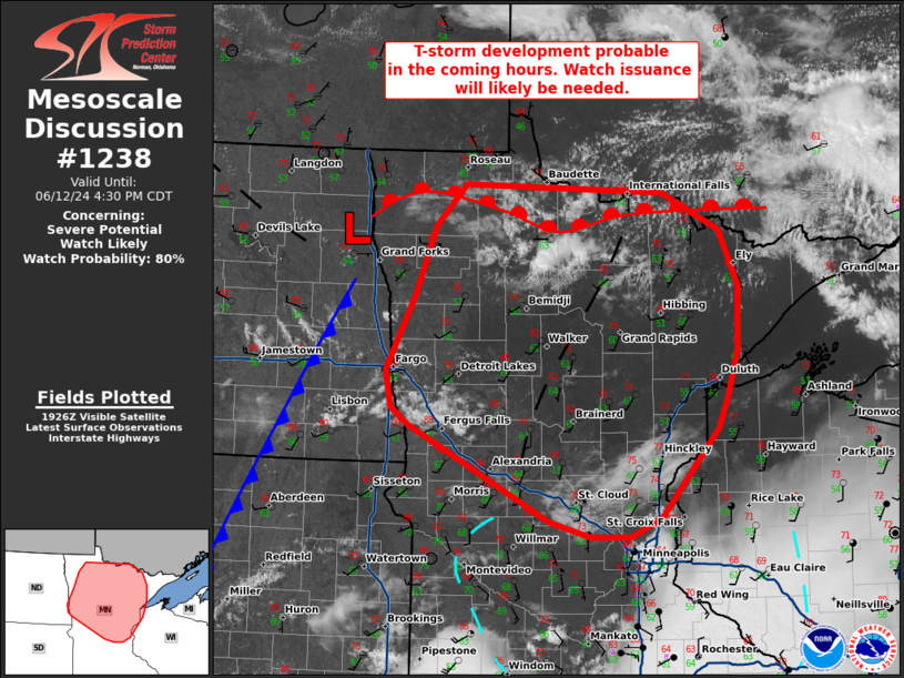
   Mesoscale Discussion 1238
   NWS Storm Prediction Center Norman OK
   0233 PM CDT Wed Jun 12 2024

   Areas affected...Central to northern Minnesota

   Concerning...Severe potential...Watch likely

   Valid 121933Z - 122130Z

   Probability of Watch Issuance...80 percent

   SUMMARY...Thunderstorm development is expected across eastern North
   Dakota and northwestern Minnesota in the coming hours. Initially
   weak cells will intensify to severe limits as they migrate into
   central and eastern Minnesota. Watch issuance is anticipated to
   address this concern.

   DISCUSSION...Recent GOES imagery shows growing cumulus with a few
   deepening mid-level towers (some with occasional lightning) in the
   vicinity of a surface low near Grand Forks, ND east/northeastward
   along a warm front into northern MN. This is likely an indication of
   increasing ascent ahead of the approaching mid-level shortwave (such
   ascent is even more evident upstream across northern MT into
   southern Saskatchewan) as well as gradual destabilization of the
   warm sector as dewpoints continue to rise into the low 60s. Recent
   RAP mesoanalyses also suggest that MLCIN is beginning to erode
   across central to northern MN. Combined with the aforementioned
   satellite trends, this suggests that convective initiation appears
   most probable across north/northwestern MN in the coming hours.

   Thunderstorms initiating in this zone will be on the northwestern
   fringe of the MLCAPE axis. Additionally, the KMVX VWP is currently
   sampling somewhat poor low-level shear given its proximity to the
   surface low; however, low-level helicity appears to be stronger
   (around 150 m2/s2 0-1 km SRH) downstream to the east of a weak
   surface confluence axis based on VWP observations from KDLH.
   Deep-layer shear is also expected to improve through the late
   afternoon/evening hours with the approach of the mid-level jet.
   Consequently, storms are expected to intensify as they migrate to
   the east/southeast towards eastern/northeastern MN. Initially
   discrete to semi-discrete cells will likely evolve into organized
   supercells with an attendant risk for severe winds, large hail
   (possibly up to 3 inches in diameter) and tornadoes (though the
   tornado threat may be conditional on establishing one or more
   dominant right-moving supercells across northeast MN, which may be
   difficult given nearly straight hodographs above 1 km). Watch
   issuance is expected in the next 1-2 hours to address this concern
   as initiation becomes more imminent.

   ..Moore/Goss.. 06/12/2024

   ...Please see www.spc.noaa.gov for graphic product...

   ATTN...WFO...DLH...MPX...FGF...

   LAT...LON   45409294 45209337 45209394 45369453 46309655 46489680
               46859689 47569648 48279618 48679576 48599291 48239208
               47689181 47069183 46599197 46289212 45409294
|
|
|
Top/All Mesoscale Discussions/Forecast Products/Home |
|