|
|
| Mesoscale Discussion 1181 | |
| < Previous MD | |

|
|
   Mesoscale Discussion 1181
   NWS Storm Prediction Center Norman OK
   1245 PM CDT Thu Jun 06 2024

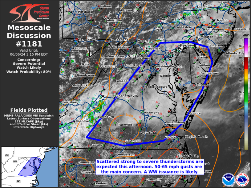
   Areas affected...portions of central and eastern Virginia into
   eastern Maryland...far southern New Jersey...Delaware

   Concerning...Severe potential...Watch likely

   Valid 061745Z - 061915Z

   Probability of Watch Issuance...80 percent

   SUMMARY...The severe threat should gradually increase through the
   afternoon, as thunderstorms become more widespread. 50-65 mph gusts
   are the main threat, and are expected to become abundant enough to
   warrant a Severe Thunderstorm Watch issuance within the next few
   hours.

   DISCUSSION...A small mid-level impulse embedded within modest
   westerlies aloft is traversing the central Appalachians, and is
   poised to approach the Atlantic Coastline this afternoon. As this
   occurs, thunderstorms should continue to increase in both coverage
   and intensity through the afternoon. Strong surface heating has
   supported low-level lapse rates to reach 7 C/km (per 17Z
   mesoanalysis), and additional heating should further boost these
   lapse rates in excess of 8 C/km. This will promote efficient
   evaporative cooling and subsequent 50-65 mph gust potential with any
   strong storm that can become sustained. A WW issuance may be needed
   in the next few hours to address the damaging gust threat.

   ..Squitieri/Smith.. 06/06/2024

   ...Please see www.spc.noaa.gov for graphic product...

   ATTN...WFO...PHI...AKQ...LWX...RNK...

   LAT...LON   36867951 38787778 39647685 39677577 39507505 39037491
               38247531 37327600 36807673 36647817 36867951
|
|
|
Top/All Mesoscale Discussions/Forecast Products/Home |
|
Source link


