|
|
| Mesoscale Discussion 1167 | |
| < Previous MD Next MD > | |

|
|
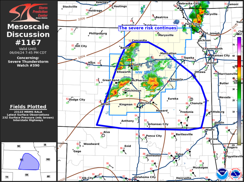
Mesoscale Discussion 1167 NWS Storm Prediction Center Norman OK 0614 PM CDT Tue Jun 04 2024 Areas affected...portions of central and southeastern KS Concerning...Severe Thunderstorm Watch 390... Valid 042314Z - 050045Z The severe weather threat for Severe Thunderstorm Watch 390 continues. SUMMARY...Upscale growth of ongoing thunderstorms appears likely this evening. Damaging winds and isolated hail are possible. A new downstream watch or an extension of WW390 will likely be needed in a couple of hours. DISCUSSION...As of 23UTC, a cluster of severe thunderstorms was ongoing over central KS with additional development occurring along the cold front to the west. The environment ahead of these storms remains favorable for damaging winds and hail with a broad warm sector, large buoyancy and sufficient deep-layer shear for storm organization. Thus far, storms have remained ahead of the front, but with the front starting to surge southeast, additional development and upscale growth appears likely over the next couple of hours. Large precipitable water values above 1.5 inches will support strong water and hail loaded downdrafts as storms merge. Several measured severe gusts have already occurred suggesting the environment is likely to remain favorable for damaging gusts this evening, especially as stronger cold pools develop. Hi-res guidance shows upscale growth into one or more clusters and eventually a line is likely as storms move east/southeast toward the OK border. As the severe threat is likely to persist into this evening, a new downstream watch or extension of WW390 may need to be considered in the next couple of hours. ..Lyons/Hart.. 06/04/2024 ...Please see www.spc.noaa.gov for graphic product... ATTN...WFO...SGF...EAX...TSA...TOP...ICT...OUN...GID...DDC... LAT...LON 37089892 38369839 39079810 39409789 39589759 39589700 39349643 39109609 38639534 38239500 37819483 37469487 37179497 37009502 36939550 36999800 37089892 |
|
|
Top/All Mesoscale Discussions/Forecast Products/Home |
|
Source link


