|
|
| Mesoscale Discussion 1161 | |
| < Previous MD | |

|
|
   Mesoscale Discussion 1161
   NWS Storm Prediction Center Norman OK
   1224 PM CDT Tue Jun 04 2024

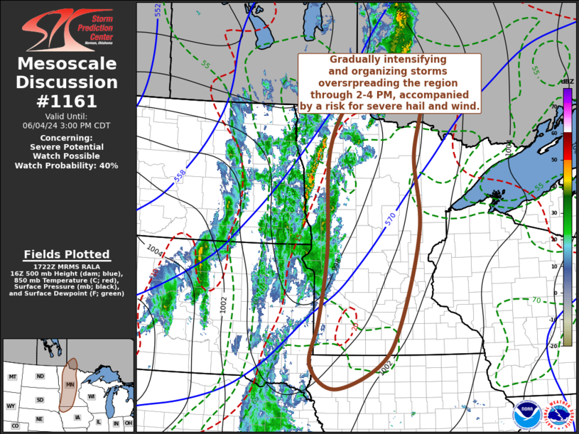
   Areas affected...much of western into central Minnesota...adjacent
   portions of eastern South Dakota and northwestern Iowa

   Concerning...Severe potential...Watch possible

   Valid 041724Z - 042000Z

   Probability of Watch Issuance...40 percent

   SUMMARY...Increasing thunderstorm development may gradually
   intensify and organize into a line while overspreading the region
   through 2-4 PM CDT.  This is expected to be accompanied primarily by
   a risk for marginally severe hail and wind, with perhaps an isolated
   tornado possible.

   DISCUSSION...Relatively deep surface troughing, near/just ahead of
   an eastward advancing cold front, appears likely to become a focus
   for gradually intensifying thunderstorm development through 19-21Z.
   It appears that this will be aided by mid/upper forcing for ascent,
   downstream of amplified mid-level troughing progressing across the
   northern Great Plains, and destabilization associated with a narrow
   corridor of deeper boundary-layer moistening.  It appears that this
   moistening will contribute to CAPE increasing up to 1500+ J/kg
   across parts of the eastern Dakotas into western Minnesota during
   the next few hours.

   Some strengthening of south-southwesterly deep-layer mean flow (from
   30-40 kt) and shear may be ongoing to the east of the Red River
   Valley.  Although low-level hodographs may be initially sizable and
   clockwise curved beneath 30 kt southerly 850 mb flow across northern
   into central Minnesota, model forecast soundings indicate that these
   will trend more linear with the approach of the front and corridor
   of increasing thunderstorm development.

   Thunderstorms seem likely to consolidate into developing a line of
   convection with primarily a marginal severe hail to wind threat.
   However, the risk for a tornado might not be completely negligible,
   mainly if a discrete storm or two can develop and be maintained
   ahead of the developing line across north central Minnesota.

   ..Kerr/Smith.. 06/04/2024

   ...Please see www.spc.noaa.gov for graphic product...

   ATTN...WFO...DLH...MPX...DMX...FGF...FSD...ABR...

   LAT...LON   49199302 47869329 46269314 44209374 43259442 42739579
               43269655 44269629 45779605 48059599 49369512 50079367
               49199302
|
|
|
Top/All Mesoscale Discussions/Forecast Products/Home |
|
Source link


