|
|
| Mesoscale Discussion 1126 | |
| < Previous MD Next MD > | |

|
|
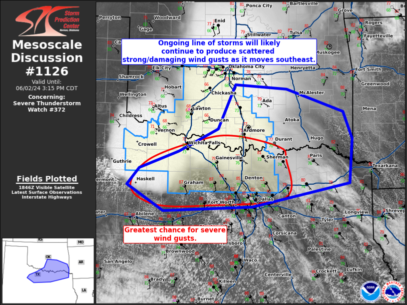
Mesoscale Discussion 1126 NWS Storm Prediction Center Norman OK 0152 PM CDT Sun Jun 02 2024 Areas affected...north/northeast Texas and southeast Oklahoma Concerning...Severe Thunderstorm Watch 372... Valid 021852Z - 022015Z The severe weather threat for Severe Thunderstorm Watch 372 continues. SUMMARY...A line of storms will likely continue as it moves southeast across southeast Oklahoma and north/northeast Texas. DISCUSSION...A line of storms with a well-established cold pool is moving across southern Oklahoma and north Texas. Significant destabilization has occurred ahead of this line with MLCAPE of 2000 to 3000 J/kg. Shear remains weak across the northern half of the line (in Oklahoma), but is somewhat better in Texas, which is where the greater severe weather threat will likely be through late afternoon. However, the well-established cold pool and downstream instability will support some severe gust threat across southeast Oklahoma through the afternoon and perhaps persisting into the evening. Watch 372 may need to be expanded across far southern Oklahoma and to the I-20 vicinity in Texas. ..Bentley/Smith.. 06/02/2024 ...Please see www.spc.noaa.gov for graphic product... ATTN...WFO...SHV...TSA...FWD...OUN...SJT... LAT...LON 33469964 33809869 34269775 35169732 35079607 34619470 34069449 33159457 32699692 32599906 33119994 33469964 |
|
|
Top/All Mesoscale Discussions/Forecast Products/Home |
|


