|
|
| Mesoscale Discussion 1120 | |
| < Previous MD | |

|
|
   Mesoscale Discussion 1120
   NWS Storm Prediction Center Norman OK
   1008 PM CDT Sat Jun 01 2024

   Areas affected...Southwest Texas

   Concerning...Severe potential...Severe Thunderstorm Watch likely

   Valid 020308Z - 020515Z

   Probability of Watch Issuance...80 percent

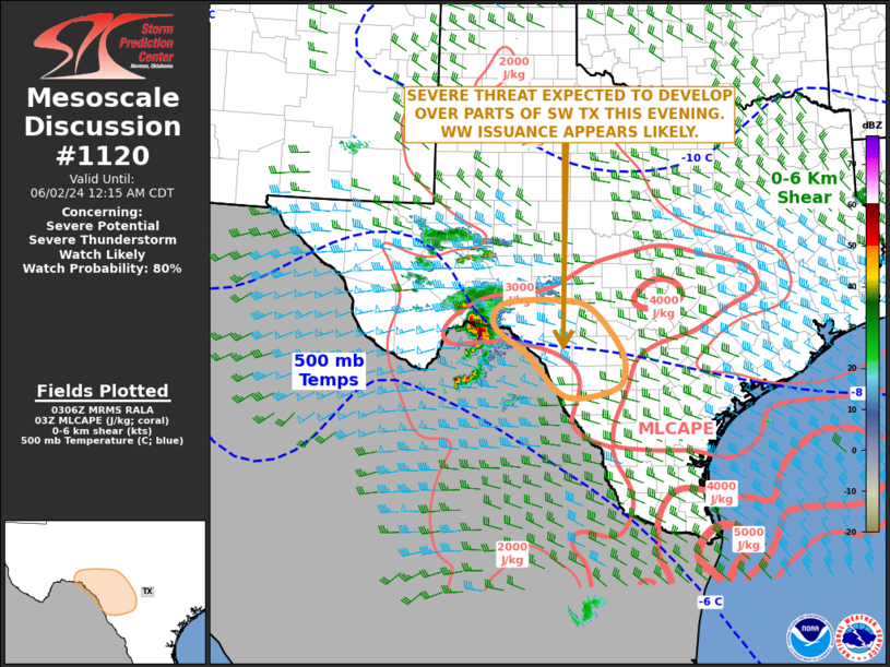
   SUMMARY...A severe threat appears likely to develop across parts of
   southwest Texas this evening. Large hail and severe wind gusts will
   be the primary threats. Weather watch issuance appears likely.

   DISCUSSION...The latest hi-resolution radar imagery near Del Rio, TX
   shows an organized bowing line segment over far northern Mexico,
   which is moving eastward around 25 knots. The storm is expected to
   move into the stronger instability across southwest Texas, where
   MLCAPE is estimated in the 3500 to 4000 J/kg range. In addition, the
   WSR-88D VWP at Del Rio has 0-6 km shear in the 35 to 40 knot range
   with a substantial amount of directional shear in the lowest 3 km.
   This shear environment will be favorable for continued severe storm
   development, as a bowing line segment remains organized and moves
   into the southwestern Texas Hill Country late this evening. Severe
   wind gusts and hail will be the primary threats.

   ..Broyles/Hart.. 06/02/2024

   ...Please see www.spc.noaa.gov for graphic product...

   ATTN...WFO...CRP...EWX...

   LAT...LON   28640045 28490002 28619934 28829904 29379909 30149974
               30270049 30220146 29980175 29700165 29300105 28640045
|
|
|
Top/All Mesoscale Discussions/Forecast Products/Home |
|
Source link


