|
|
| Mesoscale Discussion 1080 | |
| < Previous MD | |

|
|
   Mesoscale Discussion 1080
   NWS Storm Prediction Center Norman OK
   0212 PM CDT Thu May 30 2024

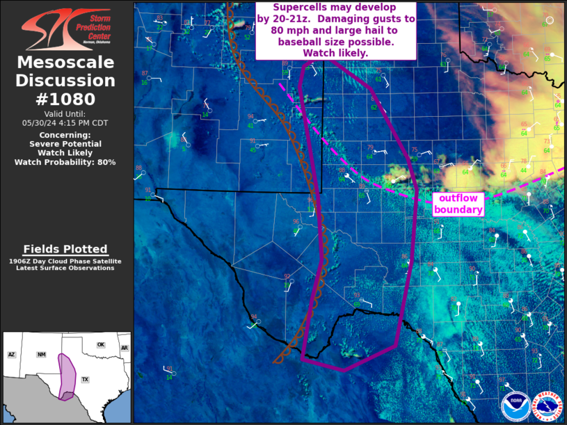
   Areas affected...far southeast NM into west Texas

   Concerning...Severe potential...Watch likely

   Valid 301912Z - 302115Z

   Probability of Watch Issuance...80 percent

   SUMMARY...Supercell thunderstorms may develop by 20-21z. Damaging
   gusts to 80 mph and large hail to baseball size will be possible
   with these storms. A tornado or two also can not be ruled out with
   any storm interacting with an outflow boundary.

   DISCUSSION...An outflow boundary continues to shift south/southwest
   across the region. Strong heating along this boundary and to the
   east of a north to south oriented dryline has aided in eroding
   capping over the region. Latest satellite imagery shows deepening
   cumulus developing along both boundaries at 19z. Isolated to widely
   scattered storms are expected to develop by 20-21z. The
   southward-advancing outflow boundary is resulting in some
   uncertainty. However, any storms developing within this strongly
   unstable environment will quickly become severe. Very steep midlevel
   lapse rates, elongated hodographs and effective shear magnitudes
   around 35 kt suggest supercells capable of significant gusts and
   very large hail will be possible.

   Low-level vorticity and SRH will be maximized along the outflow
   boundary. Any cell moving off the dryline and interacting with this
   boundary will also pose some risk for a tornado or two. A watch will
   likely be needed in the next 1-2 hours.

   ..Leitman/Guyer.. 05/30/2024

   ...Please see www.spc.noaa.gov for graphic product...

   ATTN...WFO...EWX...SJT...LUB...MAF...ABQ...

   LAT...LON   33950356 34320348 34460325 34480292 33920199 32630120
               32040100 30740113 29190149 28750256 28940344 30040325
               30770304 31930313 33950356
|
|
|
Top/All Mesoscale Discussions/Forecast Products/Home |
|


