|
|
| Mesoscale Discussion 938 | |
| < Previous MD | |

|
|
   Mesoscale Discussion 0938
   NWS Storm Prediction Center Norman OK
   0358 PM CDT Fri May 24 2024

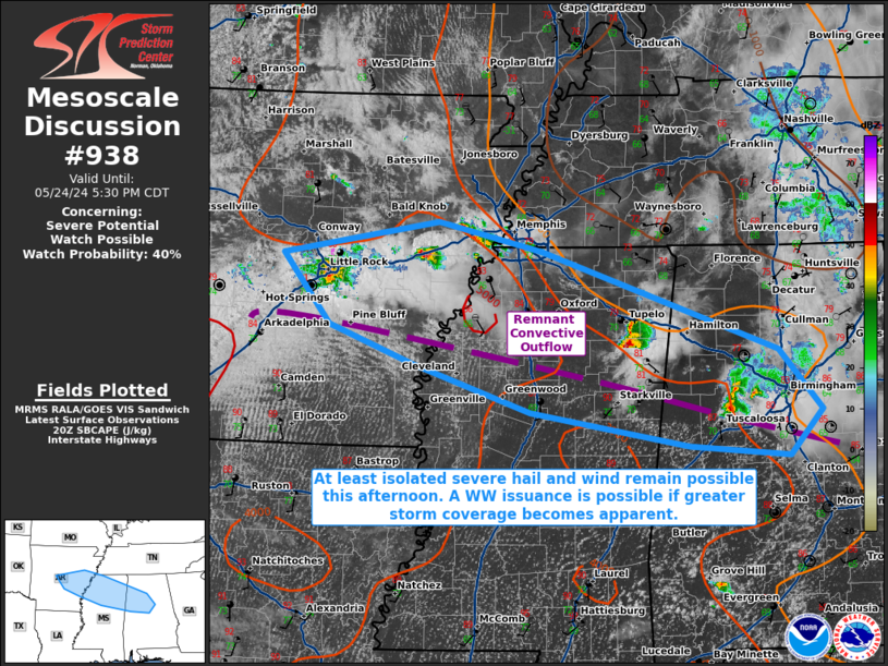
   Areas affected...portions of central Arkansas into northern
   Mississippi and Alabama

   Concerning...Severe potential...Watch possible

   Valid 242058Z - 242230Z

   Probability of Watch Issuance...40 percent

   SUMMARY...Isolated strong to severe thunderstorms continue along an
   outflow boundary across portions of the Southeast. Damaging gusts
   and hail still appear to be the main threats. Trends continue to be
   monitored for the need of a WW issuance pending an increase in
   thunderstorm coverage.

   DISCUSSION...Discrete transient supercell structures continued to
   progress along and north of an outflow boundary left behind by an
   MCS from earlier this morning. Surface temperatures have warmed into
   the upper 80s F south of the boundary, with MLCAPE increasing to
   over 3000 J/kg. Amid this environment, there has been a recent
   uptick in the intensity of the storms, with severe hail and damaging
   gusts recently reported in Pontotoc County, MS. While hail and wind
   gusts of similar caliber may occur over the next few hours, overall
   deep-layer ascent remains modest, putting overall storm coverage and
   the need of a WW issuance into question. Still, given the uptick in
   storm intensity, convective trends are being monitored for the need
   of a WW issuance should storms become more abundant.

   ..Squitieri/Guyer.. 05/24/2024

   ...Please see www.spc.noaa.gov for graphic product...

   ATTN...WFO...BMX...HUN...MEG...JAN...LZK...

   LAT...LON   34909281 35249095 34948972 33968689 33358639 32908677
               33008797 33348984 33829126 34209224 34909281
|
|
|
Top/All Mesoscale Discussions/Forecast Products/Home |
|


