|
|
| Mesoscale Discussion 773 | |
| < Previous MD Next MD > | |

|
|
   Mesoscale Discussion 0773
   NWS Storm Prediction Center Norman OK
   0616 PM CDT Mon May 13 2024

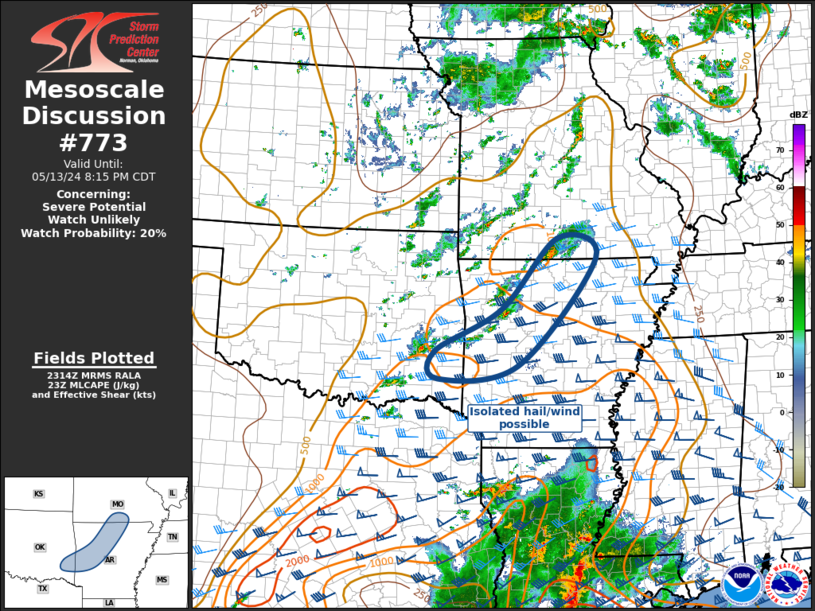
   Areas affected...MO Ozarks to Ouachita Mountains

   Concerning...Severe potential...Watch unlikely

   Valid 132316Z - 140115Z

   Probability of Watch Issuance...20 percent

   SUMMARY...Some risk for marginally severe hail and gusty winds
   exists with convection into the early evening. At this time a severe
   thunderstorm watch is not anticipated.

   DISCUSSION...Water-vapor imagery depicts a well-defined upper trough
   advancing east across eastern KS/OK into MO/AR. Cool mid-levels and
   modest deep-layer lapse rates are contributing to adequate buoyancy
   immediately ahead of this trough from southern MO into southeast OK.
   Scattered robust thunderstorms have evolved within an air mass
   characterized by roughly 1000 J/kg MLCAPE and strong surface-6km
   bulk shear. A few storms have exhibited some weak rotation and
   isolated supercells may linger through mid evening until buoyancy
   begins to wane with loss of heating. Until then, gusty winds and
   some risk for marginally severe hail can be expected with this
   activity.

   ..Darrow/Hart.. 05/13/2024

   ...Please see www.spc.noaa.gov for graphic product...

   ATTN...WFO...LZK...SGF...SHV...TSA...

   LAT...LON   34539322 34289503 34799511 35579360 36899232 36519146
               34539322
|
|
|
Top/All Mesoscale Discussions/Forecast Products/Home |
|


