|
|
| Mesoscale Discussion 686 | |
| < Previous MD | |

|
|
   Mesoscale Discussion 0686
   NWS Storm Prediction Center Norman OK
   0834 PM CDT Tue May 07 2024

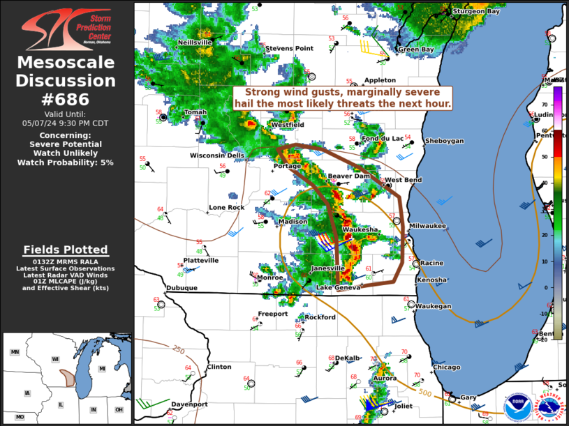
   Areas affected...Southeast Wisconsin

   Concerning...Severe potential...Watch unlikely

   Valid 080134Z - 080230Z

   Probability of Watch Issuance...5 percent

   SUMMARY...Strong wind gusts and marginally severe hail may occur
   with storms in southeast Wisconsin. Low potential for a brief
   tornado exists.

   DISCUSSION...Very modest recovery occurred behind earlier
   convection. A semi-organized line of convection will continue east
   along the cold front. The warm sector is quite narrow between the
   cold front and warm front/lake breeze boundary. Strong wind gusts
   and perhaps marginally severe hail is possible with this activity
   before weakening. Right along the boundary interface, some weak
   easterly winds exist. Some weak surface vorticity exists and could
   lead to a very brief spin-up within the line. Between diurnal
   cooling and the cooler temperatures farther east, the threat should
   last another hour or so.

   ..Wendt/Hart.. 05/08/2024

   ...Please see www.spc.noaa.gov for graphic product...

   ATTN...WFO...MKX...

   LAT...LON   42978872 43268881 43418899 43568926 43718940 43768919
               43728887 43578845 43318799 43068795 42778796 42608806
               42578836 42538870 42978872
|
|
|
Top/All Mesoscale Discussions/Forecast Products/Home |
|


