|
|
| Mesoscale Discussion 408 | |
| < Previous MD | |

|
|
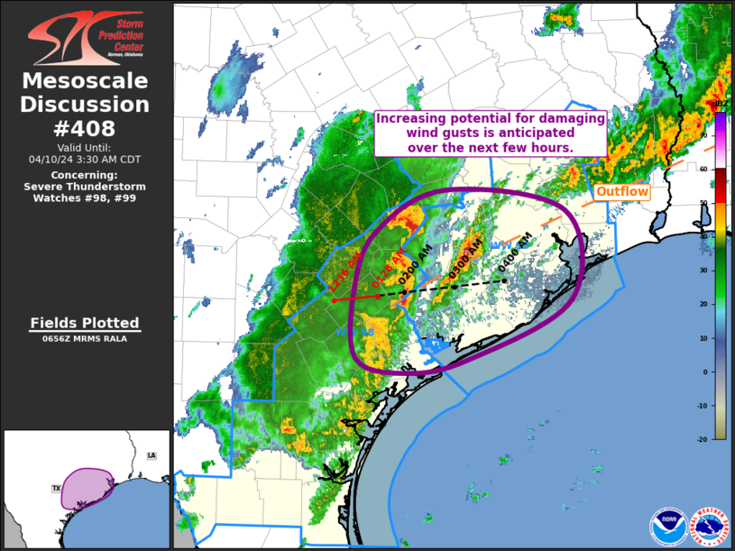
Mesoscale Discussion 0408 NWS Storm Prediction Center Norman OK 0158 AM CDT Wed Apr 10 2024 Areas affected...Middle TX Coastal Plain into Southeast TX Concerning...Severe Thunderstorm Watch 98...99... Valid 100658Z - 100830Z The severe weather threat for Severe Thunderstorm Watch 98, 99 continues. SUMMARY...Threat for damaging wind gusts continues from the Middle TX Coastal Plain into Southeast TX. An increase in the damaging wind gust potential is anticipated across southeast TX over the next few hours. DISCUSSION...Recent regional radar imagery depicts a convective line extending from Fayette County in the middle TX coastal plain south-southwestward into Brooks County in deep south TX. Updrafts within the northern portion of this line have remain relatively strong over the past hour or so. Some sharpening of the reflectivity gradient has also been noted within this portion of the line as well. The downstream airmass across southeast TX is characterized by steep mid-level lapse rates (noted in the 04Z CRP sounding) and strong buoyancy (i.e. MLCAPE over 2000 J/kg in latest mesoanalysis). Moderate vertical shear exist across the region as well, with the HGX VAD recently sampling 51 kt of 0-6 km bulk shear. This combination of buoyancy and shear should be more than sufficient for maintenance of the ongoing line, with a continued threat for damaging wind gusts and/or large hail. There is also the potential for more organization within this line as the primary shortwave currently over the southern continues to progress eastward, contributing to increase large-scale forcing for ascent. Additionally, an outflow boundary from early convection stretches across the region, evidenced by wind shift from southerly across the upper TX Coast to more northerly/northeasterly farther north. This boundary could act as a corridor of greater severe potential, particularly for damaging gusts, as it provides additional mesoscale ascent. ..Mosier.. 04/10/2024 ...Please see www.spc.noaa.gov for graphic product... ATTN...WFO...HGX...CRP...EWX... LAT...LON 28519740 29229742 29819717 30239635 30029495 29109488 28499608 28369682 28519740 |
|
|
Top/All Mesoscale Discussions/Forecast Products/Home |
|


