|
|
| Mesoscale Discussion 406 | |
| < Previous MD | |

|
|
   Mesoscale Discussion 0406
   NWS Storm Prediction Center Norman OK
   0949 PM CDT Tue Apr 09 2024

   Areas affected...southwest Oklahoma into south-central Oklahoma

   Concerning...Severe potential...Watch unlikely

   Valid 100249Z - 100345Z

   Probability of Watch Issuance...5 percent

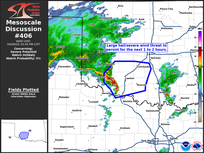
   SUMMARY...A large hail and severe wind threat will persist for the
   next 1 to 2 hours across southwest Oklahoma.

   DISCUSSION...A consolidated line of storms has developed on the
   northwestern periphery of the instability gradient across southwest
   Oklahoma. This line has organized into a small bow with several
   reports of large hail and measured severe wind gusts. Instability is
   weak in the area (~250 J/kg MUCAPE) which casts doubt on the
   longevity of the severe weather threat. However, it has been
   efficient producing severe weather in a marginal environment.
   Therefore, this bowing segment may continue to produce some large
   hail and severe wind gusts as it moves east-northeast. Dewpoints in
   central Oklahoma are in the upper 40s which may be too dry to
   support a severe weather threat. However, dewpoints have increased
   to the mid to upper 50s across southern Oklahoma which may allow the
   southern extent of this bow to continue east along the instability
   gradient into the early overnight hours.

   ..Bentley.. 04/10/2024

   ...Please see www.spc.noaa.gov for graphic product...

   ATTN...WFO...OUN...

   LAT...LON   34069874 34329892 34549917 34809916 35179877 35189805
               35129751 34949744 34659757 34439764 34299766 34069874
|
|
|
Top/All Mesoscale Discussions/Forecast Products/Home |
|


