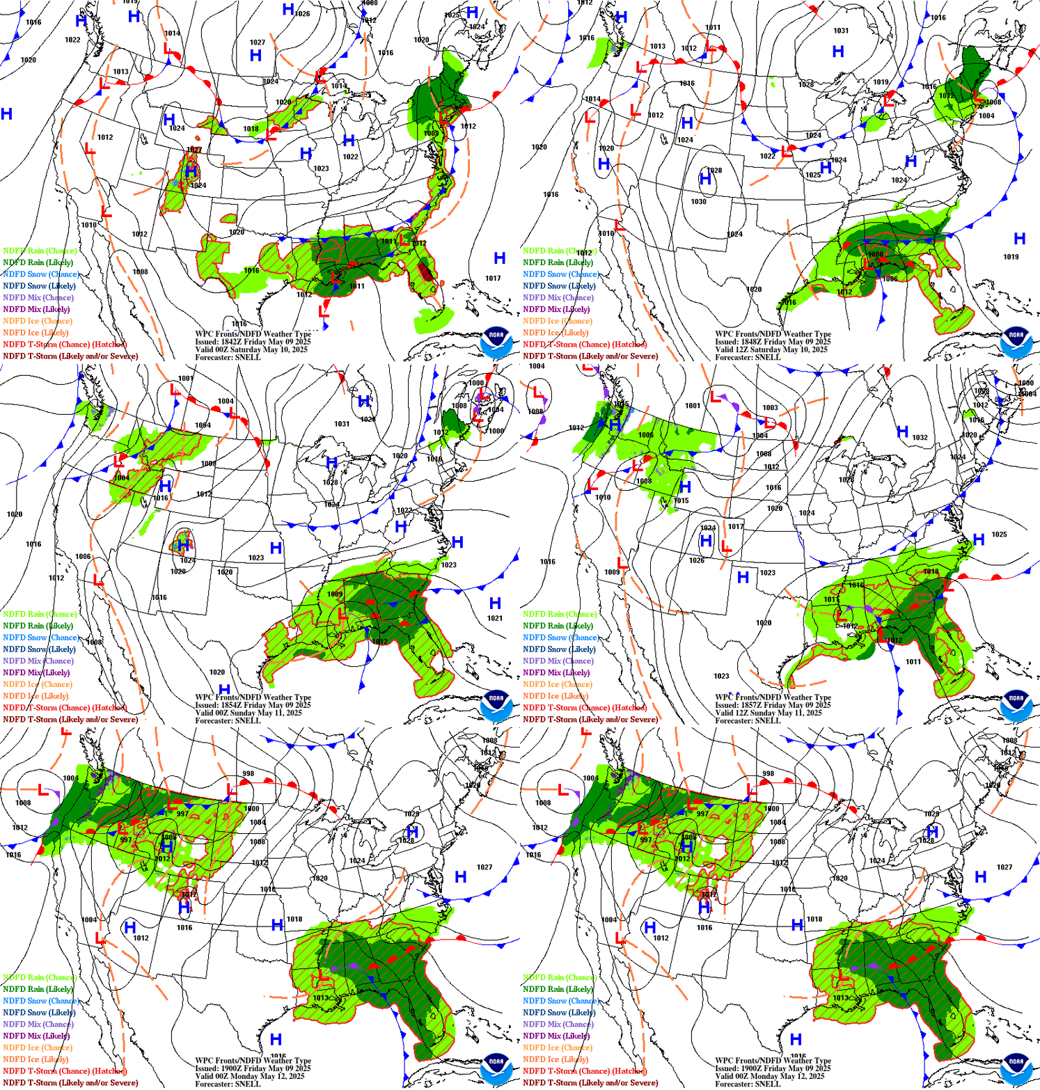
The forecasts depicted below combine WPC forecasts of fronts, isobars and high/low pressure centers with the NDFD depiction of expected weather type for days .5 to 2.5 ahead. Each frame represents 6 hours. A short range forecast discussion for the CONUS is available below the short term loop.
Short Term Forecast Frontal Systems and Isobars Loop

Short Range Forecast Discussion
FXUS01 KWBC 171919
PMDSPD

Short Range Forecast Discussion
NWS Weather Prediction Center College Park MD
318 PM EDT Fri Apr 17 2026

Valid 00Z Sat Apr 18 2026 - 00Z Mon Apr 20 2026

...Wet snow for the UP of Michigan and the Upper Midwest...

...There is a Moderate Risk (level 4/5) of severe thunderstorms
over parts of the Middle Mississippi Valley, and Central/Southern
Plains on Friday...

...There is a Slight Risk (level 2/4) of excessive rainfall over
parts of the Upper Great Lakes, Middle Mississippi Valley, and
Central/Southern Plains on Friday...

A strong front extending from the Upper Mississippi Valley to the
Central/Southern Plains on Friday will move eastward to the
Eastern Seaboard by Sunday. Showers and severe thunderstorms will
develop along and ahead of the boundary from the Upper/Middle
Mississippi Valley to the Central/Southern Plains. Therefore, the
SPC has issued a Moderate Risk (level 4/5) of severe thunderstorms
over parts of the Middle Mississippi Valleys and Central/Southern
Plains. The hazards associated with these thunderstorms are
frequent lightning, severe thunderstorm wind gusts, hail, and a
few tornadoes.

In addition, the system will produce heavy rain across parts of
the Upper/Middle Mississippi Valley, Upper Great Lakes, and the
Central/Southern Plains through Saturday morning. Therefore, the
WPC has issued a Slight Risk (level 2/4) of excessive rainfall
over parts of the Upper/Middle Mississippi Valleys and
Central/Southern Plains through Saturday morning.  The associated
heavy rain will create mainly localized areas of flash flooding,
with urban areas, roads, small streams, and low-lying areas being
the most vulnerable.

Furthermore, on Saturday, showers and severe thunderstorms will
develop over the Lower Great Lakes/Ohio Valley/Central
Appalachians. Therefore, the SPC has issued a Slight Risk (level
2/5) of severe thunderstorms over parts of the Lower Great
Lakes/Ohio Valley/Central Appalachians through Sunday morning.
The hazards associated with these thunderstorms are frequent
lightning, severe thunderstorm wind gusts, hail, and a few
tornadoes. Moreover, on Sunday, rain will develop along the East
Coast, with showers and thunderstorms, and extend into the Gulf
Coast, lingering over southern Texas on Sunday evening. Also on
Sunday, light wet snow will develop over parts of the Upper
Peninsula of Michigan and the Upper Midwest.

Meanwhile, an upper-level trough over the Northern Plains on
Friday will move to the Great Lakes by Saturday and the Northeast
by Sunday.  The system will produce late-season light snowfall
over the Northern/Central Rockies and the Upper Great Lakes,
Friday night into Saturday, and over the Upper Mississippi
Valley/Upper Great Lakes Saturday into Sunday. An approaching cold
front over the Northeast Pacific on Saturday will produce rain
over the Northwest on Saturday and Northwest and Northern
California on Sunday.


Ziegenfelder


Graphics available at
https://www.wpc.ncep.noaa.gov/basicwx/basicwx_ndfd.php


$$
Depicted Weather Types
- NDFD Rain (Chance) – There is chance of measurable rain (≥0.01″) at the valid time.
- NDFD Rain (Likely) – Measurable rain (≥0.01″) is likely at the valid time.
- NDFD Snow (Chance) – There is chance of measurable snowfall (≥0.01″ liquid equivalent) at the valid time.
- NDFD Snow (Likely) – Measurable snow (≥0.01″ liquid equivalent) is likely at the valid time.
- NDFD Mix (Chance) – There is a chance of measurable mixed precipitation (≥0.01″ liquid equivalent) at the valid time. “Mixed” can refer to precipitation where a combination of rain and snow, rain and sleet, or snow and sleet are forecast.
- NDFD Mix (Likely) – Measurable mixed precipitation (≥0.01″ liquid equivalent) is likely at the valid time. “Mixed” can refer to precipitation where a combination of rain and snow, rain and sleet, or snow and sleet are forecast.
- NDFD Ice (Chance) – There is a chance of measurable sleet and/or freezing rain (≥0.01″ liquid equivalent) at the valid time.
- NDFD Ice (Likely) – Measurable sleet and/or freezing rain (≥0.01″ liquid equivalent) is likely at the valid time.
- NDFD T-Storm (Chance) – There is a chance of thunderstorms at the valid time. Areas are displayed with diagonal hatching enclosed in a dark red border.
- NDFD T-Storm (Likely and/or Severe) – Thunderstorms are likely and/or the potential exists for some storms to reach severe levels at the valid time.

