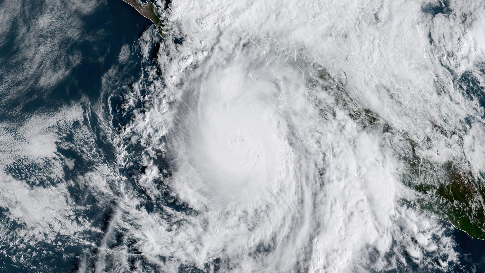
Hurricane Lidia was on a straight-shot course on Tuesday to slam into the Mexican coast close to Puerto Vallarta by evening. Lidia’s winds increased by 35 mph from Monday to Tuesday morning, just hitting the official threshold for rapid intensification (30 knots or 35 mph in 24 hours). At 11 a.m. EDT Tuesday, Lidia’s top sustained winds were up to 100 mph, making it a Category 2 hurricane, and its central pressure was down to 971 millibars. Lidia was located about 195 miles west-southwest of Puerto Vallarta, moving east-northeast at 15 mph.
After struggling for days to organize a large field of showers and thunderstorms (convection), Lidia was gaining traction on Tuesday morning, with a cloud-filled eye just becoming apparent on satellite imagery and an intense central core of convection. Conditions are ripe for Lidia to intensify right up until landfall, as the storm is embedded in rich moisture (mid-level relative humidity around 67 percent) and passing over very warm sea surface temperatures of 30-31 degrees Celsius (86-88 degrees Fahrenheit). Although upper-level winds near Lidia are increasing, these winds will likely produce an outflow jet that would more than compensate for increased wind shear, and Lidia has a chance to reach Category 3 strength just before it comes ashore. Lidia’s strong onshore winds will push upslope against rugged terrain just inland, dumping widespread 4-to-8-inch rains that could exceed 12 inches in some area, bringing flash floods and mudslides across and near Nayarit state. Lidia’s projected landfall near Puerto Vallarta raises the risk of significant storm surge in and near the bay the city lies on, Banderas Bay.

The coast of southwestern Mexico is no stranger to hurricanes, but only a few have been recorded this close to Puerto Vallarta in the era of reliable Northeast Pacific records, which goes back roughly half a century (see Figure 1 above). The two strongest to make landfall near and north of Puerto Vallarta (thus putting the city on the more dangerous right-hand side) were Category 4 Kenna in 2002 and Category 3 Roslyn in 2022; both came ashore roughly 60-80 miles north of the city. Both hurricanes led to four deaths; Kenna injured more than 100 people from Puerto Vallarta to San Blas, damaging or destroying thousands of structures. Patricia, the strongest Eastern Pacific landfalling hurricane on record, moved onshore as a small but mighty top-end Category 4 storm about 80 miles south of Puerto Vallarta. And in 2011, category 2 Jova came ashore about 70 miles to the south of the city. The closest pass to Puerto Vallarta was from Calvin in 1993 and Eugene in 1997, but both hurricanes were tracking north-northwest roughly parallel to the coast, keeping storm surge minimal.
Tropical Storm Max the second Pacific named storm to hit Mexico in 2023
Tropical Storm Max made landfall around 2 p.m. EDT Monday just to the west of Puerto Vicente Guerrero in the Mexican Provence of Guerrero with sustained winds of 65 mph and a central pressure of 991 mb. Max’s torrential rains brought significant flash flooding near the landfall region and to the southeast, in Acapulco. Max dissipated over the high terrain of Mexico on Tuesday morning.
Max is the second Pacific named storm to hit Mexico in 2023; on August 20, Tropical Storm Hilary made landfall in San Quintín, Baja California about 215 miles south-southeast of San Diego, California, with sustained winds of 65 mph. In addition, the center of Hurricane Beatriz passed within five miles of the Mexican coast near Manzanillo on July 1. Last year, five Pacific named storms made landfall in Mexico, including three hurricanes.
Typhoon Bolaven batters the Northern Mariana Islands
Typhoon Bolaven passed through the channel between Rota and Tinian islands in the U.S. Northern Mariana Islands early Tuesday morning U.S. EDT (late Tuesday night local time). As of 7 p.m. local time Tuesday, the National Weather Service on Guam reported that Bolaven had brought rains of 3-5 inches, and could bring storm total amounts of 8-12 inches, with isolated higher amounts. At 10 a.m. EDT Tuesday, buoy 52211 in the islands was reporting a significant wave height of 14.1 feet; seas were predicted to peak at 20-24 feet in portions of the islands.
At 12Z Tuesday (8 a.m. EDT, 10 p.m. local time in Guam), Bolaven had top sustained one-minute average winds of 85 mph and was headed north-northwest at 12 mph, away from the Northern Mariana Islands, according to the Joint Typhoon Warning Center. The Japan Meteorological Agency rated Bolven as having a central pressure of 970 mb and 80 mph winds (10-minute average, which is normally substantially lower than the 1-minute average used by the National Hurricane Center and Joint Typhoon Warning Center). Guam radar on Tuesday showed the outer bands of Bolaven were still lashing the islands, which were under a Flash Flood Watch.
The Joint Typhoon Warning Center predicted that Bolaven would rapidly intensify into a category 4 typhoon with 145-mph winds by Thursday. No land areas lie in Bolaven’s path as it recurves to the north and northeast this week.
A late-season Cabo Verde system is likely to develop this week
A tropical wave located several hundred miles southwest of the Cabo Verde Islands on Tuesday afternoon, designated Invest 92L, was headed west-northwest to northwest toward the remote central Atlantic. This wave has considerable support for development from the models and is likely to form into a tropical depression this week. In its Tropical Weather Outlook issued at 8 a.m. EDT Tuesday, the National Hurricane Center gave 92L two-day and seven-day odds of development of 70% and 80%, respectively. The next name on the Atlantic list is Sean.

Disturbance in the Bay of Campeche will feed into heavy U.S. Gulf Coast rains
An area of disturbed weather in the Gulf of Mexico’s Bay of Campeche, designated Invest 93L, was growing more organized on Tuesday morning, and surface pressures were falling in the area. Satellite images of 93L on Tuesday afternoon showed a modest amount of heavy thunderstorms that were beginning to show rotation. A hurricane hunter aircraft is scheduled to investigate the disturbance on Tuesday afternoon.
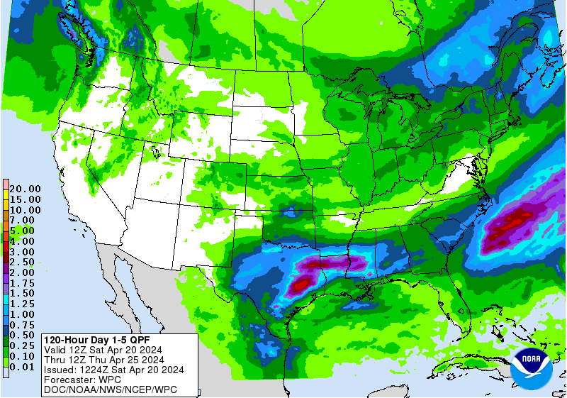
The disturbance is expected to move slowly north toward Texas through Wednesday morning, then recurve to the northeast by Wednesday afternoon as it gets absorbed into a frontal zone, bringing heavy rains of two to five inches to the northern Gulf Coast and Southeast U.S. through the weekend. Moisture from Tropical Storm Max and Tropical Storm Lidia in the eastern Pacific will also feed into these rains, as seen in Figure 2 above. In its Tropical Weather Outlook issued at 8 a.m. EDT Tuesday, the National Hurricane Center gave 93L two-day and seven-day odds of development of 30%.
Website visitors can comment on “Eye on the Storm” posts (see comments policy below). Sign up to receive notices of new postings here.
Source link