A surface low just offshore of the Carolinas, strengthening on Friday afternoon, evolved into Tropical Storm Ophelia at 1 p.m. EDT Friday. Ophelia will sweep into eastern North Carolina on Saturday and continue north into Virginia and the Delmarva Region by Sunday, spawning multiple nearshore hazards and bringing a broad swath of the U.S. East Coast a stormy weekend. Tropical Storm Warnings were in effect from Cape Fear, North Carolina, to Fenwick Island, Delaware, as well as for several bays and sounds just inland. Heavy rains were already pushing into North Carolina on Friday afternoon, well ahead of the low itself.
Ophelia was centered at 1 p.m. EDT about 150 miles southeast of Cape Fear, North Carolina, with top sustained winds already at 60 mph. Ophelia could strengthen a bit more before landfall early Saturday, although it is not predicted to reach hurricane strength. The storm had a buoy-measured surface pressure of 996 millibars and sustained winds of 50 mph northwest of its center at 11 a.m. EDT Friday, when it was still designated as Potential Tropical Cyclone 16.
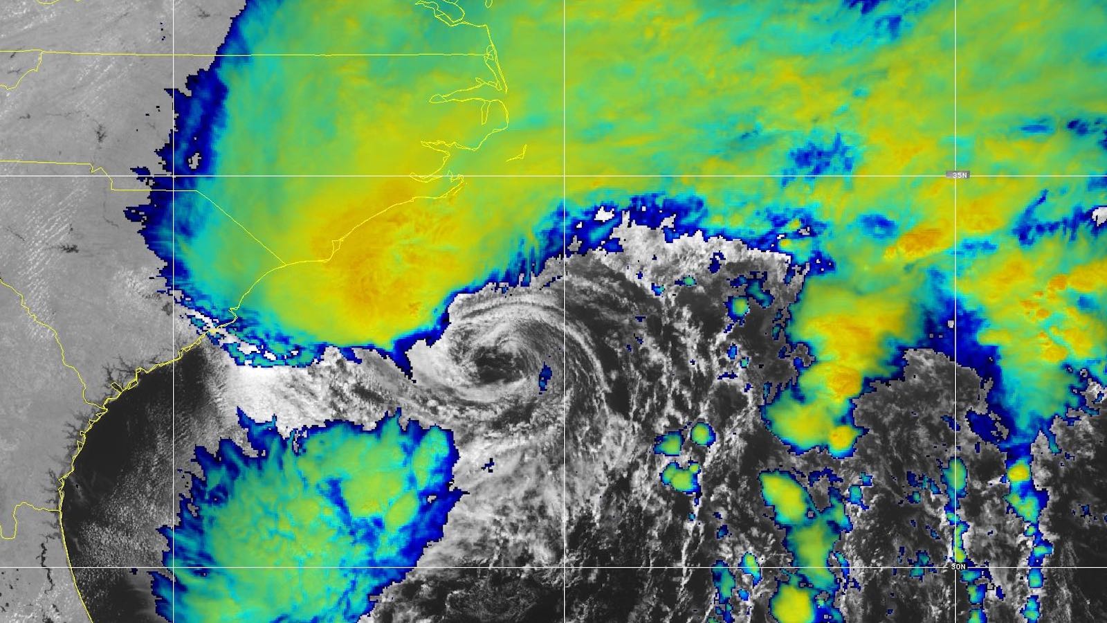
A distinct, exposed low-level swirl was evident on satellite (see image at top), with showers and thunderstorms — convection — blossoming to its north and along a cold front displaced well to the east. The multiple frontal boundaries interacting with Ophelia and the system’s asymmetric structure were producing a comma-shaped cloud pattern more typical of a subtropical than a tropical storm. However, it appears reconnaissance data from a Hurricane Hunter flight helped convince the National Hurricane Center that the system had earned the tropical storm designation.
Track and intensity forecast
The big-picture prognosis for Ophelia this weekend is fairly straightforward, but there are devils in the details. Models are in strong agreement that the storm will move northward into eastern North Carolina on Saturday and continue into eastern Virginia on Sunday. Weak steering currents may allow Ophelia to linger and gradually weaken in the vicinity of Delmarva into Monday, and its longer-term track is quite uncertain.
The waters off the Carolina coast have been untouched by tropical cyclones since Tropical Cyclone Idalia moved offshore in late August. Sea surface temperatures of 28-29 degrees Celsius (82-84 degrees Fahrenheit) are about 0.5-1.0°C (1-2°F) warmer than average for this time of year, more than warm enough to nurture a tropical storm.
The storm surge threat: Moderate to major coastal flooding possible in southeast Virginia and the Delmarva
Ophelia is on track to bring a smorgasbord of impacts to a heavily populated area on a busy September weekend.
The track of the intensifying low will favor strong east to northeast winds pushing water into shores, bays, and inlets from the Outer Banks to the Delmarva. Waves of 10-15 feet will be riding into the coast atop the storm surge. A storm surge warning was in effect from Beaufort Inlet, North Carolina, to Chincoteague, Virginia, including parts of the Chesapeake Bay and Pamlico and Albemarle Sounds as well as the Neuse and Pamlico Rivers. How high the water rises will depend on the amount of storm-produced surge as well as the timing of the arrival of peak surge. Peak astronomical tides will be boosted slightly by the fall equinox, which arrives early Saturday morning, September 23.
The highest surge, perhaps reaching inundation levels of three to five feet, was predicted for the Pamlico, Pungo, Neuse, and Bay Rivers. Potential inundations of two to four feet are possible northward across the Outer Banks and Lower Chesapeake Bay, as well as the Lower Potomac extending close to the Washington, D.C., area. Inundations of one to three feet are possible for the Upper Chesapeake and Delaware Bays and the southern coast of New Jersey coast.
Below is a sampling of crests predicted on outlets near the coast for Saturday afternoon and evening; how those predicted crests would rank among the long-term National Weather Service gauge records at each site, where available; and expected flood impacts at or near the predicted values. The Hampton Roads area of southeast Virginia, including Norfolk, appears to be at the highest risk of major flooding among urban areas near the coast.
- Delaware Bay at Lewes, Delaware: Eight feet (eigth-highest in the long-term record). At eight feet, “flooding starts to become severe enough to begin causing structural damage along with widespread flooding of roadways in the coastal communities of Sussex County. Vulnerable homes and businesses may be severely damaged or destroyed as water levels rise further above this threshold.”
- Atlantic coast near Ocean City Inlet, Maryland: 4.9 feet. At five feet, “Widespread flooding of vulnerable areas will result in an elevated threat of property damage to homes and businesses near the waterfront and shoreline.”
- James River at Sewells Point, Virginia (Norfolk): 6.4 feet (13th-highest in the long-term record). At 6.5 feet, “Severe flooding will cause extensive inundation of numerous roads and buildings … Some areas will need to be evacuated.”
Winds, rains, and possible tornadoes
The strongest winds can be expected east of Ophelia’s center from Friday night into Saturday morning across eastern North Carolina. Sustained winds could reach 40 to 60 mph, especially across the Pamlico Sound and Outer Banks, more than enough to damage trees and power lines.
Heavy rains will intensify over eastern North Carolina and work their way up the East Coast from Friday afternoon into Saturday with the approach of Ophelia, posing the threat of localized flash flooding. The heaviest totals, perhaps six to 10 inches, can be expected near and just north of the storm’s center as it pushes onshore. Totals of four to six inches may be quite common from eastern North Carolina into southeast Virginia and much of the Delmarva, and a solid two- to four-inch drenching can be expected over most areas east of the Appalachians from Virginia, Maryland, and the Delmarva into Pennsylvania and New Jersey, as well as New York and southern New England.
Tornadoes will be possible ahead of Ophelia, especially late Friday into early Saturday across southeast Virginia and northeast North Carolina. Moist onshore flow will be increasing, enhancing both instability and the vertical wind shear that supports rotating thunderstorms. The NOAA/NWS Storm Prediction Center placed this area under a slight risk (level 2 of 5) for severe weather through early Saturday.

The Atlantic’s next disturbance may become a tropical depression or tropical storm over the weekend
A large but still-disorganized system west of the Cabo Verde Islands is on track to become the Atlantic’s next named storm, perhaps just after the system near the U.S. East Coast. Designated as Invest 90L, the disturbance showed increasing spin on Friday, and a large area of showers and thunderstorms was gradually organizing. In its Tropical Weather Outlook issued at 8 a.m. EDT Friday, the National Hurricane Center gave 90L a 70% chance of development over the next two days, with a 90% chance over the next week. With a moist atmosphere and very warm sea surface temperatures ahead of its path (around 29°C or 84°F), 90L may be able to fend off moderate to strong wind shear of 10-20 knots and gradually intensify over the next several days. The next name on the Atlantic list after Ophelia is Philippe.
Through this weekend, 90L is expected to continue moving west-northwest across the central tropical Atlantic. Beyond that point, it appears increasingly likely that 90L will angle northwestward next week, staying clear of the Lesser Antilles much as Lee and Nigel did. It is too soon to entirely rule out the idea of 90L entering the Caribbean, as any approach to the islands would still be five to seven days from now. However, nearly all of the ensemble members of the Thursday-night runs of the European and GFS model angle 90L away from the islands and into the open Atlantic.
Nigel is no more
Former Category 2 Hurricane Nigel was declared a post-tropical cyclone at 5 a.m. EDT Friday almost exactly a week after it emerged as a tropical depression in the central tropical Atlantic. Nigel was spinning more than 600 miles north-northwest of the Azores, and it is expected to merge with a mid-latitude storm this weekend. The National Hurricane Center typically maintains advisories on a post-tropical cyclone as long as warnings are still in effect, but Nigel’s entire life has played out without incident in the remote North Atlantic east of the Caribbean and Bermuda, so the early-Friday advisory was the final one for Nigel.
Jeff Masters contributed to this post. Website visitors can comment on “Eye on the Storm” posts (see comments policy below). Sign up to receive notices of new postings here.
Source link