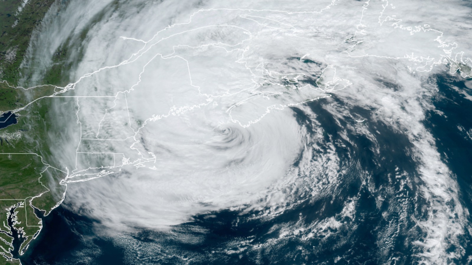
Once a category 5 monster, Post-Tropical Cyclone Lee was pushing into far western Nova Scotia and New Brunswick on Saturday much larger in size but much weaker in strength than during its time in the tropics. Ferry crossings were cancelled across much of Atlantic Canada as the provinces hunkered down for high winds, rough seas, and heavy rain. Pockets of flooding were reported in Nova Scotia by early afternoon Saturday, including at Peggys Cove on the rugged southwest coast.
As expected, the biggest impacts from Lee’s approach were trees, tree limbs, and power lines knocked down by high winds. As of 2 p.m. EDT Saturday, power outages associated with Lee were affecting about 94,000 customers in Maine, 140,000 in Nova Scotia, and 37,000 in New Brunswick, according to poweroutage.com.
The ill-defined center of Lee was passing just offshore of western Nova Scotia early Saturday afternoon, en route to New Brunswick. Lee’s top sustained winds at 2 p.m. EDT were estimated by the National Hurricane Center at 70 mph, making it equivalent to a high-end tropical storm. At Brier Island on the western tip of Nova Scotia, sustained winds peaked at 53 mph gusting to 64 mph around 6 a.m. EDT. Lee’s breadth brought strong winds well to the east of the storm’s center: Halifax, in central Nova Scotia, recorded winds of 41 gusting to 67 mph at 11 a.m. EDT. Winds were generally below tropical storm strength across Maine, on the weaker western side of Lee.
Rains are often heavier on the western side of a landfalling Atlantic tropical or post-tropical cyclone. In the case of Lee, the heavier rains have been east of the center across Nova Scotia. A CoCoRaHS observer seven miles south of Yarmouth reported 2.20 inches as of 7:30 a.m. EDT., and 1-2″ totals were widespread across southwestern parts of the province. Totals in Maine were generally less than an inch through Saturday morning, though a large band of rain pushing westward across the state could bring another inch or two to many areas. As of 1 p.m. EDT, Bar Harbor had received 1.46 inches.
Lee caused a storm surge of about two feet at Nantucket Island, Massachusetts, which brought minor flooding at the time of high tide early Saturday morning. A storm surge of up to five feet was predicted for Canada’s Bay of Fundy.
A Friday-night sunset spectacular, courtesy of Lee
As Lee headed north on Friday, an unusually dramatic sheaf of banded cirrus outflow clouds spread across the Northeast U.S. and Atlantic Canada, which ended up giving millions of people a stunning sunset on Friday night.
Margot on its way to oblivion
Tropical Storm Margot is still spinning in the remote central North Atlantic, about 700 miles west-southwest of the Azores, but is steadily degrading because of high wind shear, dry air, and cool sea surface temperatures near 26 degrees Celsius (79°F). Margot is expected to become post-tropical by Wednesday, when it will potentially be moving into the western Azores.

Tropical Depression 15 expected to become a hurricane
At 11 a.m. EDT Saturday, Tropical Depression 15 was located in the waters of the tropical Atlantic midway between the Lesser Antilles and Cabo Verde Islands, headed north-northwest at 18 mph, with top sustained winds of 35 mph and a central pressure of 1006 mb. Satellite images early Saturday afternoon showed that TD 15 was poorly organized, with an ill-defined surface circulation center and not a lot of heavy thunderstorms.
As it moves north-northwest over the next several days, TD 15 will have favorable conditions for development: light to moderate wind shear (5-15 knots), sea surface temperatures of 29-30 degrees Celsius (84-86°F), and a moist atmosphere. The National Hurricane Center is predicting that TD 15 will become Tropical Storm Nigel by Saturday night and Hurricane Nigel by Monday. The top models continue to be in strong agreement that steering currents will take TD 15 on a path that will recurve the storm by midweek to the north and northeast, well east of Bermuda, likely making TD 15 a “fish” storm of concern only to marine interests. However, residents of Bermuda will want to monitor forecasts for TD 15 in case this turn occurs later than expected.

Next tropical wave
A number of members of the GFS and European ensemble models are predicting that another tropical wave will emerge from the coast of Africa on Wednesday and then develop late next week in the central tropical Atlantic. This wave will potentially follow a more westerly course than TD 15 and will bear watching in case it threatens the Caribbean islands. In its 2 p.m. EDT Saturday Tropical Weather Outlook, the National Hurricane Center gave this future system two-day and seven-day development odds of 0% and 30%, respectively. The next name on the Atlantic list of storms after Nigel is Ophelia.
Website visitors can comment on “Eye on the Storm” posts (see comments policy below). Sign up to receive notices of new postings here.
Source link


