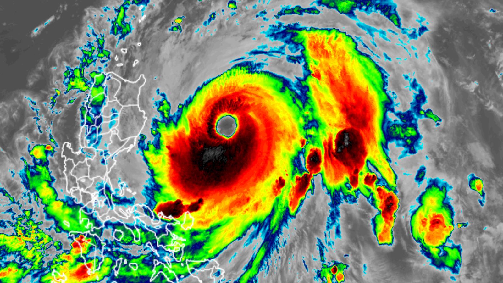
After a burst of rapid intensification, Typhoon Doksuri was roiling the waters northeast of the Philippines at 11 a.m. EDT Monday as a category-4-equivalent. According to the Joint Typhoon Warning Center, Doksuri’s top one-minute sustained winds were 140 mph, which gave the typhoon the strength of a category 4 hurricane. Doksuri is the second-strongest typhoon so far this year, behind only category 5 Mawar, which passed near Guam and the Philippines in late May without a direct landfall. Doksuri is a name contributed by South Korea that means “eagle.” In the Philippines, which for decades has used a naming system apart from the rest of the Northwest Pacific, Doksuri is called Egay.
After a slow westward trek for several days, Doksuri angled northwest while rapidly strengthening on Sunday. That general northwestward motion may be enough to prevent Doksuri from striking the Philippines’ main island of Luzon head-on, though the eye of the storm may pass over tiny Babuyan Island (population 2,000) to the north of Luzon. However, the storm’s weaker left-hand (southwest) side will move across northern parts of Luzon, bringing torrential rains, potentially damaging winds, and coastal flooding.
Doksuri should remain a powerful typhoon over the open waters northeast of the Philippines, where it will draw on warm sea surface temperatures of 29-30 degrees Celsius (84-86°F) as well as an area of enhanced deeper oceanic heat content. Upper-level wind shear should remain light to moderate (5-15 knots), and the typhoon’s large envelope of rich atmospheric moisture will help insulate it from any rapid weakening. It appears most likely that Doksuri will pass just south of Taiwan on Wednesday, but there is still a wide degree of spread in the track among models, including the European and GFS models and their ensembles (see Figures 1 and 2). Only a slight rightward angling would bring Doksuri’s center into Taiwan.


Even without a landfall, intense showers, thunderstorms, and fierce winds on the typhoon’s stronger right-hand side could sweep across southern and western parts of Taiwan. These rains could actually be a boon to the drought-stricken nation, which has a limited ability to store water and experienced no typhoon landfalls during the period from 2020 to 2022, a span dominated by La Niña. As reported by NPR, rice farmers in southern Taiwan were prohibited from planting each spring from 2021 through 2023 so that water would be available for semiconductor factories. Taiwan manufactures the bulk of the entire world’s semiconductor chips.
Doksuri is expected to accelerate northwestward on Wednesday and Thursday, most likely reaching the coast of southeast China by late Thursday or Friday. It’s too soon to predict the precise location or strength of this landfall with any confidence. At that point, Doksuri’s strength will depend largely on how much it has interacted with the Philippines and Taiwan, with this interaction likely to potentially cause significant weakening.

Disturbance 95L approaching the Lesser Antilles not expected to develop
After losing a battle with dry air, tropical disturbance 95L, located a few hundred miles east of the Windward Islands on Monday afternoon, has seen its chances of development plummet over the past few days. Satellite images Monday afternoon showed that 95L’s heavy thunderstorm activity had increased since Sunday, but the system no longer had much spin. Conditions were marginally favorable for development, with moderate wind shear of 10-20 knots and warm sea surface temperatures of 29 degrees Celsius (84°F).
Forecast for 95L
95L is predicted to move westward at 15-20 mph this week and bring heavy rain showers and gusty winds to the Lesser Antilles Islands beginning on Monday evening. High wind shear of 20-25 knots on Tuesday through Thursday should keep any development of 95L slow to occur, and the system has very little model support for development. In its 8 a.m. EDT Monday Tropical Weather Outlook, the National Hurricane Center gave 95L two-day and seven-day odds of development of 20%. The Hurricane Hunters are on call to investigate 95L on Wednesday afternoon when it is expected to be in the central Caribbean.
A new tropical wave over Africa to watch
A tropical wave located over extreme western Africa on Monday afternoon is predicted to move off the coast by Tuesday, then speed west to west-northwest across the tropical Atlantic during the week. By Monday, July 31, the wave is expected to be near the Leeward Islands, and there is some support for development at that time from the GFS model and its ensemble members. This wave has not yet received mention from the National Hurricane Center in their Tropical Weather Outlook but will likely get mentioned later this week.
Don finally dies
Long-lived Hurricane Don finally died on Monday morning, July 24, over the cold waters east of Newfoundland, Canada. Don became the season’s first hurricane on Saturday, July 22, about three weeks earlier than the usual appearance of the season’s first hurricane: August 11. Don lasted a total of nine days after its formation as a subtropical storm on July 14. According to the National Hurricane Center, Don is the fifth-longest-lasting system on record for July, just behind Emily of 2005. Mostly thanks to Don, the season’s accumulated cyclone energy is about double the average for this point in the season: 16.2, compared to the 1991-2020 average of 8.8.
Website visitors can comment on “Eye on the Storm” posts (see comments policy below). Sign up to receive notices of new postings here.
Source link


