Tropical Storm Julia, which formed along the northern coast of Venezuela at 11 a.m. EDT Friday with top sustained winds of 40 mph, is expected to intensify into a hurricane and bring dangerous heavy rains to much of Central America and southeastern Mexico. Julia is predicted to make landfall in Nicaragua on Sunday morning.
Julia’s formation date of October 7 comes about two weeks later than the typical September 22 appearance of the season’s 10th named storm. This season’s activity now stands at 10 named storms, four hurricanes, and two major hurricanes, with an Accumulated Cyclone Energy (ACE) index 78% of average for the date. The 1991-2020 averages for October 7 are 11.6 named storms, 5.6 hurricanes, and 2.5 major hurricanes. So in spite of the catastrophic rampage of Ian, the Atlantic as a whole is still having a slightly less active season than usual.
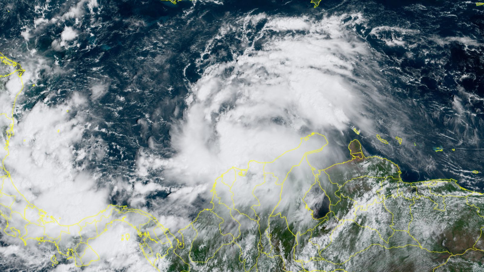
Julia formed in an unusual location for a tropical cyclone: very near the coast of Venezuela. When it was a tropical depression, between 11 p.m. EDT Thursday and 8 a.m. EDT Friday, Julia passed over two peninsulas of Venezuela, the Paraguaná and Guajira, that jut northward into the Caribbean. Only one other tropical cyclone in NOAA records has made it farther south into Venezuela: Tropical Storm Bret (1993), which moved bodily through interior northern Venezuela and produced devastating floods, killing more than 200 people.


On Friday afternoon, Julia was bringing heavy thunderstorms to northern Venezuela and Colombia, as seen on satellite imagery. Julia had a modest-sized amount of heavy thunderstorms that were gradually increasing in areal coverage and organization, with substantial low-level spiral banding beginning to occur. Close proximity to the coast of South America was interfering with development, though.
Forecast for Julia
A ridge of high pressure to the north of Julia will keep it moving on a westward trajectory at about 15 mph through early next week, with its center just off the coast of South America through Friday afternoon. Except for its close proximity to land, conditions for development of Julia will be favorable, with warm waters near 29.5 degrees Celsius (85°F), moderate wind shear of 10-15 knots, and a moist atmosphere (a mid-level relative humidity of 75-80%).


Models are in good agreement on the forward speed of Julia, with the storm gradually slowing down from its current 18-mph forward speed to about 12 mph at the time of landfall in Nicaragua on Sunday morning. Once Julia is inland, the models indicate a likely bend toward the west-northwest, which would keep the center over land until it dissipates. The models are tightly clustered in their track forecast for Julia, and a landfall in Nicaragua is very likely, with the Colombian islands of San Andres and Providencia off the coast of Nicaragua also at risk.
After Julia pulls away from the coast of South America on Friday afternoon, a period of steady intensification is expected, and a burst of more rapid strengthening is possible from Saturday into early Sunday. The western Caribbean this weekend will have favorable conditions for Julia to spin up into a hurricane, and this portion of the Atlantic is notorious for seeing some outlandish rapid intensification events. The 6Z Friday runs of the top two intensity models, the HMON and HWRF, show Julia reaching category 2 strength with 100-mph winds at landfall on Sunday morning in Nicaragua. At 12Z Friday, the statistics-based SHIPS and DTOPS rapid intensification tools both gave odds of close to 30 percent that Julia would be near hurricane strength by Saturday morning, and SHIPS gave a 29 percent chance that Julia will be packing 105-mph sustained winds (category 2) by Sunday morning.


Heavy rains the main threat
The main threat from Julia will be its dangerous heavy rains of 5 – 10 inches, with some higher amounts, expected over large portions of Central America and southeastern Mexico beginning on Saturday. Much of Central America, including the portion of eastern Nicaragua where Julia’s heaviest rains will fall, has been relatively dry over the past three months, receiving rainfall 50 – 80% of average. However, the arrival of heavy rains in northwestern Honduras will be unwelcome: The region is dealing with flooding as a result of heavy rains that hit during the last week of September. That flooding on the Ulúa River in the Sula Valley killed 12 people and led to the evacuations of 16,000 people. Saturated soils in the region will lead to more flooding if any rains of consequence fall from Julia. The 0Z Friday run of the European model (Figure 3) predicted that Julia would bring 5-day rainfall amounts of 5 – 10 inches to northwestern Honduras.
Website visitors can comment on “Eye on the Storm” posts (see comments policy below). Sign up to receive notices of new postings here.
Source link