
|
|
| Mesoscale Discussion 665 | |
| < Previous MD | |
|
|
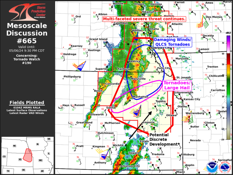
Mesoscale Discussion 0665 NWS Storm Prediction Center Norman OK 0806 PM CDT Mon May 06 2024 Areas affected...Northeast Kansas into Southeast Nebraska Concerning...Tornado Watch 190... Valid 070106Z - 070230Z The severe weather threat for Tornado Watch 190 continues. SUMMARY...A multi-faceted severe threat continues across northeast Kansas into southeast Nebraska. Damaging winds and tornadoes will be the main hazards. Some discrete activity is still ongoing and will pose the greatest tornado threat this evening as well as large/very-large hail. DISCUSSION...A linear segment northwest of Topeka is moving northeast. This activity is likely to be the focus for wind damage potential over the next 1-3 hours. Manhattan ASOS observed a 52 kt wind gust as the line passed. KTWX also showed embedded circulations within this line. Given the environment observed on the KTWX VAD and the observed 00Z TOP sounding, the potential for tornadoes will continue even with linear storm modes. Additionally, discrete storms are ongoing southwest of the linear segment. These storms will similarly pose a threat for tornadoes (potentially strong) as well as a threat for large/very-large hail. There is shower/weak thunderstorm activity south of Topeka that may eventually mature. These storms would likely be discrete initially and should be monitored over the next few hours. ..Wendt.. 05/07/2024 ...Please see www.spc.noaa.gov for graphic product... ATTN...WFO...EAX...OAX...TOP...ICT... LAT...LON 39859693 40269684 41039653 41049587 40849537 39859491 39219496 38379499 38079538 38089589 38569723 38819750 39859693 |
|
|
Top/All Mesoscale Discussions/Forecast Products/Home |
|