The National Hurricane Center began issuing advisories on Potential Tropical Cyclone 13 (PTC 13) at 11 a.m. EDT Thursday, for a tropical wave previously designated Invest 91L in the southern Caribbean. This system will bring heavy rains capable of causing flash flooding to the ABC Islands and coast of northern South America through Friday, and it is predicted to develop into a hurricane on Sunday, when it is expected to hit Nicaragua.
On Wednesday, torrential rains from PTC 13 caused widespread flooding in Trinidad and Tobago, with the government reporting 75 flooding incidents and 18 landslides. Two people were swept away by floodwaters; one was rescued, but the other person remains missing. Schools were closed in Trinidad and Tobago on Thursday, as a “yellow alert” was issued for river flooding from the storm.
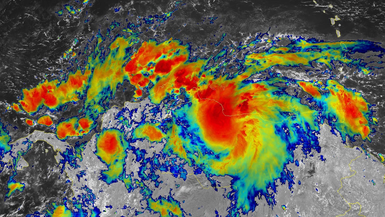
On Thursday morning, PTC 13 was bringing wind gusts of more than 30 mph to the ABC Islands, and satellite imagery and Curaçao radar showed heavy thunderstorms affecting the ABC Islands and adjacent coast of South America. PTC 13 had a modest-sized area of poorly organized heavy thunderstorms that were gradually increasing in areal coverage, but no well-defined circulation center was apparent. Close proximity to the coast of South America was interfering with development.
A ridge of high pressure to the north of PTC 13 will keep it moving on a westward trajectory at about 15 mph through early next week, with its center just scraping the northern coast of South America through Friday afternoon. Except for its close proximity to land, conditions for development of PTC 13 will be favorable, with warm waters near 29.5 degrees Celsius (85°F), light to moderate wind shear of 5-15 knots, and a moist atmosphere (a mid-level relative humidity of 75%). The main threat posed by PTC 13 through Friday will be heavy rains of 3 – 6 inches along the coast of South America and the adjacent ABC islands.
PTC 13 continues to have strong model support for development, with the odds highest on Friday afternoon, once PTC 13 pulls away from the coast of South America and enters the southwestern Caribbean. PTC 13 is not expected to threaten the northern Caribbean islands or the United States.


Models are in good agreement on the forward speed of PTC 13, with a landfall in Nicaragua on Sunday the most likely prospect; the Colombian islands of San Andres and Providencia off the coast of Nicaragua will also be at risk. A more west-northwesterly track and a landfall in Honduras or the southern Yucatan Peninsula is looking less probable than it was yesterday.
Assuming no substantial development occurs until Friday, PTC 13 will have just a limited amount of time for intensification before making landfall. Nevertheless, the western Caribbean this weekend is expected to have highly favorable conditions for PTC 13 to spin up into a hurricane, and this portion of the Atlantic is notorious for seeing some outlandish rapid intensification events. Most models show PTC 13 making landfall as a strong tropical storm or category 1 hurricane on Sunday in Nicaragua, but a higher landfall intensity cannot be ruled out, such as the category 3 landfall that the 6Z Thursday run of the HWRF model was portraying.
After landfall, PTC 13 will continue moving west to west-northwest across Central America, and it could potentially become a named storm in the Eastern Pacific. Though not yet mentioned in the NHC forecast, PTC 13 likely will bring dangerous heavy rainfall of 3 – 6 inches, with some higher amounts, to portions of Honduras, Guatemala, El Salvador, Belize, Costa Rica, Panama, and southeastern Mexico early next week.
In its 11 a.m. EDT Thursday advisory, NHC gave PTC 13 2-day and 5-day odds of development of 90%. The next name on the Atlantic list of storms is Julia.
Tropical Depression 12 on its last legs
Born on Tuesday, Tropical Depression 12 (TD 12) is expected to be gone by Friday without ever reaching tropical storm strength. As of 11 a.m. Thursday, TD 12 consisted of little more than a low-level circulation in the eastern tropical Atlantic, with top sustained winds of 35 mph, and very little heavy thunderstorm activity. High wind shear is expected to make TD a remnant low by Friday.
Bob Henson contributed to this post.
Website visitors can comment on “Eye on the Storm” posts (see comments policy below). Sign up to receive notices of new postings here.
Source link