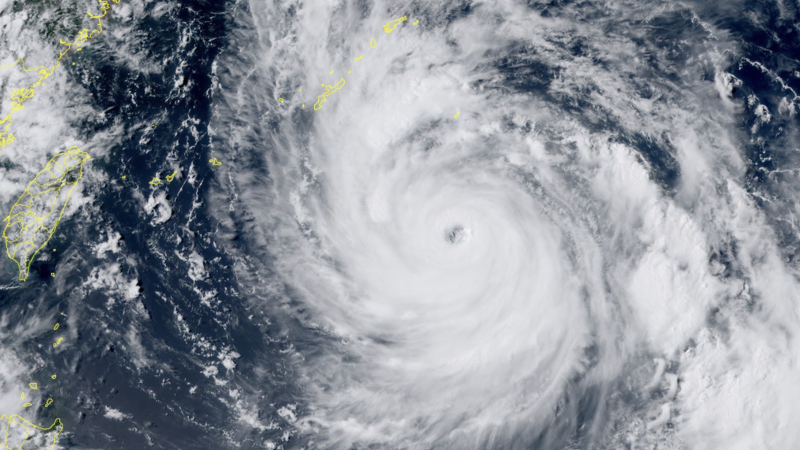
Sprawling Typhoon Khanun is on track to bring torrential rains and high winds to several of Japan’s Kyushu Islands, including Okinawa, and it may take awhile to depart. A burst of rapid intensification took Khanun’s top 1-minute sustained winds from 80 mph (category 1 strength) at 2 a.m. EDT Sunday to 130 mph (category 4 strength) at 2 a.m. EDT Monday, July 31, according to the Joint Typhoon Warning Center.
Khanun is not only intense but also quite large. As of 8 a.m. EDT Monday, Khanun’s hurricane-force sustained winds extended across a span of more than 160 miles, and tropical-storm-force winds spanned roughly 460 miles.
A gentle leftward swing in Khanun’s northwest track is predicted to take it just southwest of Okinawa on Tuesday night local time, which would put the island on the typhoon’s stronger right-hand side. The typhoon is expected to still be in the category 3 or 4 range by that point, so sustained winds could easily top hurricane force and perhaps exceed 100 mph if the center moves over or near Okinawa. Gale-force winds – enough to topple trees and power lines – will likely affect most or all of the island for hours. The United States’ Kadena Air Force Base on Okinawa has an extensive guide to help personnel deal with the storms that pass through what it calls “Typhoon Alley.”
Khanun’s departure from Okinawa is more uncertain than its arrival. The upper-level high now steering Khanun will break down by midweek, leaving the typhoon somewhat adrift for what could be several days. The 12Z Monday run of the GFS model stalls Khanun about halfway between Okinawa and the coast of China on Thursday, then brings the system back closer to the island for several more days. The 06Z Monday run of the European model was roughly similar. As shown in Figure 1 below, the ensemble runs of these two models lend further credence to the possibility, with many (though not all) ensemble members showing a stall and an eventual swing back northeast.

If Khanun stalls as expected, the storm’s broad circulation will churn up cooler water and eventually lead to weakening, though that could be a gradual process. All told, the Kyushu Islands should prepare for prolonged high winds and very heavy rains that could extend over much of this week.
Invest 96L struggles to develop in the open Atlantic
A tenacious disturbance called Invest 96L may yet develop into a tropical cyclone, though it won’t be threatening any land areas. Centered about 650 miles northeast of the northern Leeward Islands early Monday afternoon, 96L consisted of a distinct low-level swirl, with gale-force winds on its eastern side, embedded in strong wind shear of 20 knots.

Westerly upper-level flow was blowing 96L’s showers and thunderstorms (convection) well to the east of the center, and mid-level relative humidity was a meager 50 percent. Warm sea surface temperatures of 28-29 degrees Celsius (82-84°F) are working in 96L’s favor, and the system may organize modestly as it continues northwest across the open subtropical Atlantic well east of Bermuda over the next couple of days. Beyond that point, cooler water and ever stronger wind shear should lead to its demise.
Model support has diminished somewhat for 96L, but most members of the 12Z Monday GFS ensemble continue to develop 96L into at least a tropical depression, while the 6Z European ensemble was much less supportive.

In its Tropical Weather Outlook issued at 2 p.m. Monday, the National Hurricane Center gave 96L a 60 percent chance of developing into at least a tropical depression over the next two days, and 70 percent odds over the next seven days.
Further north, Invest 97 – what’s left of a low-pressure center that affected the Southeast U.S. coast over the weekend – had raced northeastward over cooler waters by Monday and merged with a frontal system. This system was given two- and seven-day odds of development of a mere 10 percent, and even that slim chance will most likely be gone by Tuesday.
Jeff Masters contributed to this post. Website visitors can comment on “Eye on the Storm” posts (see comments policy below). Sign up to receive notices of new postings here.
Source link