Tropical Storm Julia has intensified substantially over the warm waters of the southwest Caribbean. As of 11 a.m. EDT Saturday, October 8, Julia was about 265 miles east of Bluefields, Nicaragua, racing west at 21 mph and packing top sustained winds of 65 mph. With favorable conditions for strengthening through Saturday night, Julia could rapidly intensify into at least a category 1 hurricane, perhaps a Cat 2, before striking the east coast of Nicaragua on Sunday morning.
Torrential rains from Julia may bring widespread flooding in Central America, parts of which are still recovering from two destructive hurricanes in 2020.
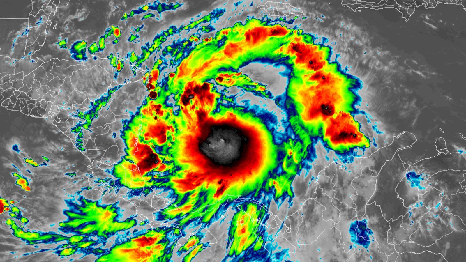
After racing over coastal Venezuela Thursday night into Friday morning, becoming one of the Caribbean’s most southerly tropical cyclones on record, Julia continued west on Friday and gradually gained distance from the South American coast. On Friday night, bursts of intense showers and thunderstorms (convection) consolidated into an impressive central dense overcast (CDO). However, reconnaissance flights on Saturday morning confirmed that Julia was not yet vertically aligned: northerly wind shear of around 15 knots had driven the strongest shower and thunderstorm activity (convection) south of the lowest surface pressure.
Forecast for Julia
Julia’s intensification on Friday night gave it an unfortunate head start on what could be a dangerous period of strengthening. Conditions are close to ideal for development across the southwest Caribbean, with sea surface temperatures near 30 degrees Celsius (86 degrees Fahrenheit), wind shear dropping into the light-to-moderate range (around 10 knots), and a very moist mid-level atmosphere (relative humidity 80-85 percent). As Julia intensifies, it will be moving near the Colombian islands of San Andrés and Providencia on Saturday evening, with its center possibly passing over San Andrés.
The 12Z Saturday run of the SHIPS statistical model gives Julia a 62% percent chance of reaching category 2 strength (sustained winds of 85 knots) by Sunday morning and a 42% chance of achieving category 3 strength (95 knots). The more advanced DTOPS statistical model gives only 11% and 7% chances of these outcomes. Given its continued fast motion, Julia probably has less time to strengthen before landfall than these 24-hour forecasts imply, so a Cat 1 landfall (as predicted by the HWRF intensity model) or perhaps Cat 2 (as predicted by the HMON intensity model) appear to be most likely.
With less than 24 hours before landfall, Julia is unlikely to go through an eyewall replacement cycle, so it should remain a relatively small hurricane. Wind impacts should therefore remain focused near and just north of Julia’s center at landfall.
As Julia barrels into the coast of Nicaragua early Sunday morning, its extremely moist air will be forced upslope against rugged terrain, leading to dangerous heavy rains of 5 – 10 inches and localized totals of 10 – 15 inches, over large portions of Central America and southeastern Mexico. One positive sign is that Julia is now projected to continue moving at a fairly brisk pace of 10 – 15 mph during and after landfall, which will help to limit the total rainfall at any one spot.
Rainfall the biggest hazard from Julia
Much of Central America, including the portion of eastern Nicaragua where Julia’s heaviest rains will fall, has been relatively dry over the past three months, receiving rainfall of 50 – 80% of average. However, the arrival of heavy rains in northwestern Honduras will be unwelcome: The region is dealing with flooding as a result of heavy rains that hit during the last week of September. That flooding on the Ulúa River in the Sula Valley killed 12 people and led to evacuations of 16,000 people. Saturated soils in the region will lead to more flooding if rains of consequence fall from Julia.


Julia is expected to rapidly weaken as it moves into or near El Salvador. However, with Julia moving more quickly and further south than earlier expected, it may emerge into the Pacific as a tropical depression or tropical storm by Monday, or regain such strength once it’s over water. Such a track is now predicted by most of the GFS and European ensemble models. In its 8 a.m. Saturday Tropical Weather Outlook, the National Hurricane Center gave a 20% chance of development or redevelopment into at least a tropical depression between Monday and Thursday. The name Julia will be kept only if an identifiable circulation survives the trek across Central America; otherwise, the name Roslyn from the Eastern Pacific list would be used for any redevelopment.


Central America still recovering from two catastrophic 2020 hurricanes
Much of Central America is still recovering from two catastrophic category 4 hurricanes that hit in November 2020. Slow-moving Hurricane Eta hit northeastern Nicaragua with 140 mph winds and lingered over Central America for three days, dumping widespread torrential rains in excess of 20 inches that killed 382 people, primarily in Guatemala, Honduras, Mexico, and Panama. Eta was the fourth-deadliest November or December Atlantic hurricane to occur, according to statistics from NHC.
Just two weeks after Hurricane Eta’s devastating impact came Hurricane Iota, the latest category 5 storm ever recorded in the Atlantic. Iota made landfall as a category 4 storm with 155 mph winds in northeastern Nicaragua, just 15 miles from where Eta hit. There is no precedent in the Atlantic for two such powerful hurricanes to make landfall so close together in space and time. Iota brought torrential rains that inundated flooded regions still struggling to recover from Eta, killing 39 people in Central America and 23 in Colombia.


The twin hurricanes displaced 1.5 million people; in Honduras alone, 3.4 million people were left in urgent need of aid, and the nation has not fully recovered, according to the International Rescue Committee. According to EM-DAT, the international disaster database, the combined impact of the two hurricanes on Nicaragua was $930 million – about 9% of that nation’s GDP. Eta caused $2.4 billion in damage to Guatemala, about 3% of GDP. But the twin category 4 hurricanes left behind a truly extreme catastrophe in Honduras. Total damages from the hurricanes exceeded $5 billion – a colossal 20% of the poverty-stricken nation’s GDP, or roughly comparable to the economic toll wreaked on Honduras by catastrophic Hurricane Mitch in 1998. The destruction from Eta and Iota drove a large migration of destitute people from Honduras to other nations, including to the U.S.
In an email this week, journalist Jeff Ernst, based in Honduras, wrote: “A lot of infrastructure has not yet been fully repaired from the destruction caused by hurricanes Eta and Iota in 2020, notably including many levees. Coincidentally, just this week, residents in some of the areas that were flooded by the hurricanes in 2020 have been protesting and demanding that the government finish repairing the levees and build more dams for a long-term solution.”
According to the Famine Early Warning System, the current food situation in Honduras and Nicaragua puts them at the “Stressed” (yellow alert) level. Portions of Guatemala are at the “Crisis” (orange alert) level.
Website visitors can comment on “Eye on the Storm” posts (see comments policy below). Sign up to receive notices of new postings here.
Source link