
Hurricane Nigel is intensifying over the warm waters of the remote central Atlantic and is expected to become the season’s fourth major hurricane on Tuesday. At 11 a.m. EDT Monday, Nigel was located 875 miles east-southeast of Bermuda, headed northwest at 12 mph, with top sustained winds of 80 mph and a central pressure of 984 mb. The National Hurricane Center was predicting that Nigel’s winds would increase by 35 mph in a 24-hour period, which would meet the minimum definition of rapid intensification. This would make Nigel a Category 3 hurricane with 115 mph winds on Tuesday.
Beyond Tuesday, Nigel will be encountering cooler waters, higher wind shear, and drier air, which are expected to weaken the hurricane as it recurves to the north and northeast, well away from any land areas. By Saturday, Nigel is expected to become a post-tropical storm.
A very busy Atlantic hurricane season
Nigel’s ascension to hurricane status gives the Atlantic 15 named storms, six hurricanes, three major hurricanes, and an accumulated cyclone energy (ACE) index of 108 so far in 2023. In comparison, the long-term averages for the period 1991-2020 for the entire season were 14.4 named storms, 7.2 hurricanes, 3.2 major hurricanes, and an ACE of 123, so we’re already close to having a full season’s worth of activity here in mid-September, with a month of the peak part of hurricane season still to come. The pace of Atlantic activity in recent weeks has been record-setting, as documented in the Tweets below.
Next tropical wave
A number of members of the GFS and European ensemble models are predicting that a tropical wave will emerge from the coast of Africa on Wednesday and then develop late in the week in the central tropical Atlantic. Preliminary indications are that this wave will take a track far enough to the northwest to avoid the Caribbean islands, but it is too early to be confident of this forecast. In its 8 a.m. EDT Monday Tropical Weather Outlook, the National Hurricane Center gave this future system two-day and seven-day development odds of 0% and 70%, respectively. The next name on the Atlantic list of storms is Ophelia.
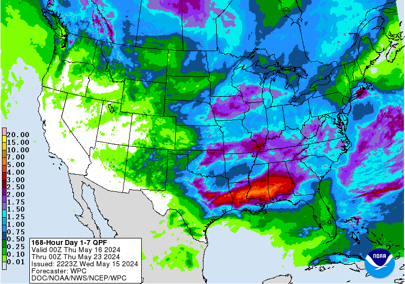
Watching the Southeast U.S. coast late this week
The GFS and European models and many of their ensemble members are predicting that a nontropical area of low pressure will develop along the Southeast U.S. coast on Thursday or Friday. This system has the potential to evolve into a tropical or subtropical storm by Saturday if its center remains over water. Regardless of development, the system is likely to bring heavy rains to the coast; the latest NOAA quantitative precipitation forecast calls for two to five inches of rain along the coast from northern Florida to Virginia by next Monday. Coastal flooding from an extended period of strong onshore winds will also be a concern. In its 8 a.m. EDT Monday Tropical Weather Outlook, the National Hurricane Center gave this future low two-day and seven-day development odds of 0% and 30%, respectively. The next name on the Atlantic list of storms after Ophelia is Philippe.
No new post on the Atlantic tropical weather is planned for Tuesday and Wednesday, but this post will be updated if there are any significant forecast changes.
Bob Henson contributed to this post.
Website visitors can comment on “Eye on the Storm” posts (see comments policy below). Sign up to receive notices of new postings here.
Source link