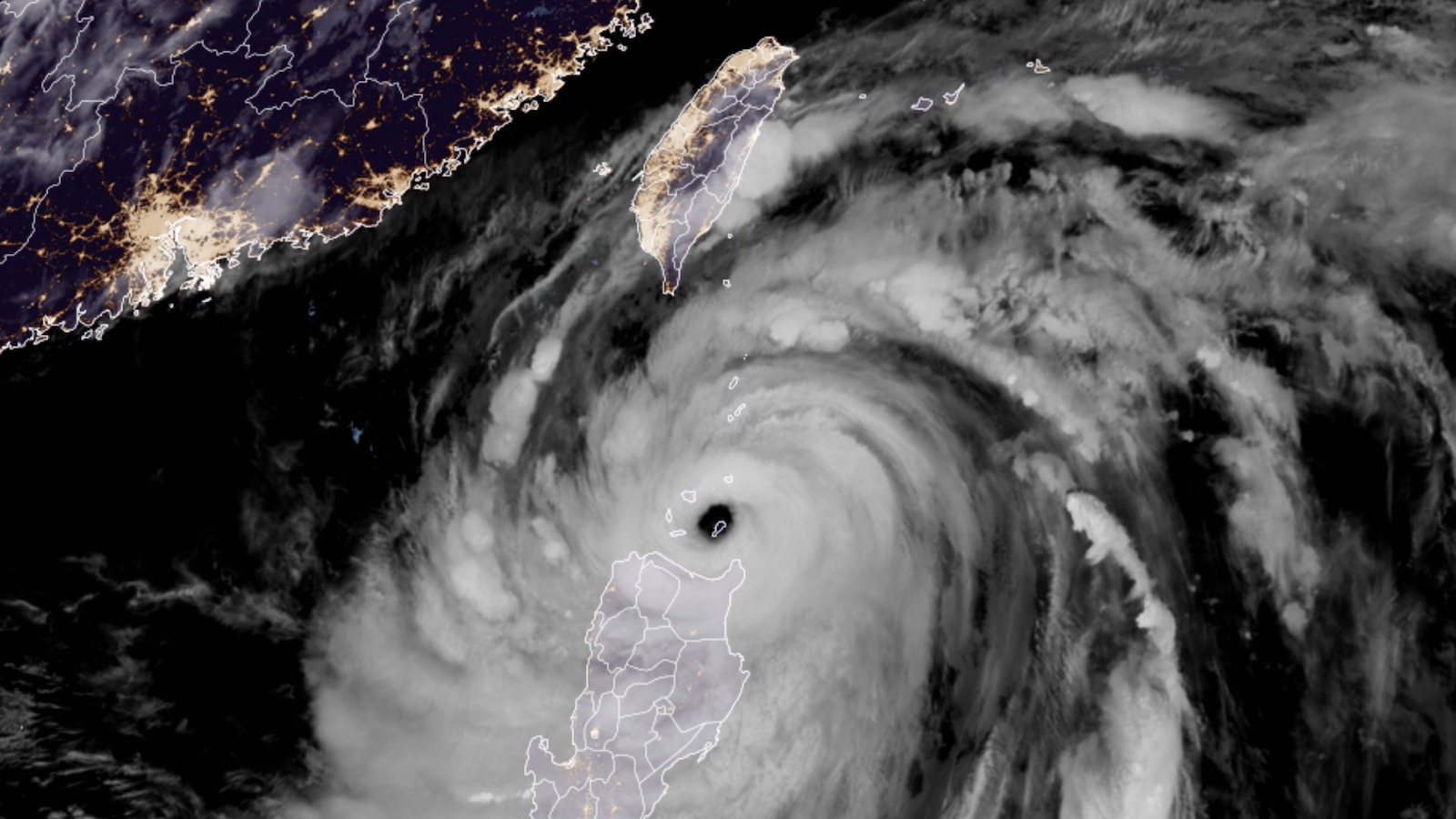
Slightly weakened, but still a formidable storm, former Super Typhoon Doksuri was passing just north of the main Philippines island of Luzon on Tuesday. At 11 a.m. EDT Tuesday, according to the Joint Typhoon Warning Center, Doksuri was located about 35 miles northeast of the northeast tip of Luzon, moving west-northwest at 11 knots (about 13 mph). Top sustained winds (1-minute) were pegged at 120 knots (140 mph), making Doksuri the equivalent of a category 4 hurricane.
Doksuri’s slight weakening was in part due to an eyewall replacement cycle in progress; over the course of a day or so, such cycles typically cut the strength of a hurricane or typhoon by about one category on the Saffir-Simpson scale, after which a storm can reintensify if conditions are favorable. In this case, land interaction from its track near the Philippines and Taiwan may keep Doksuri from regaining its previous strength, but warm sea-surface temperatures and light wind shear will help limit the weakening. Moreover, larger storms like Doksuri tend to weaken more slowly.
As the weaker left-hand side of Doksuri passes just north of Luzon, the northernmost parts of the island can expect widespread tropical-storm-force winds, with higher gusts possible near the coast and at the higher elevations of the Sierra Madre and Cordillera Central ranges. Widespread rainfall of 4-8” and localized totals above 8” are expected.
The most direct impacts on the Philippines will be across the small Babuyan (Calayan) Islands just north of Luzon. Interaction with the island of Luzon appears to have induced a short-term leftward shift in Doksuri’s track that brought the large 40-mile-diameter eye directly over Camiguin Island (pop. 92,000), which is sparsely populated but a popular tourist destination.
Doksuri will also pass over or near several other Babuyan islands on Tuesday night local time. Further north, the Batanes Islands will be brushed by the outer edge of Doksuri’s intense right-hand side. The Basco radar site in the Batanes, roughly 100 miles north of Doksuri’s center, recorded sustained winds of 121 mph at 11 a.m. EDT Tuesday.
Large-scale steering currents should put Doksuri back on a northwestward track after it clears the Philippines. There is still disagreement among the European and GFS model ensembles on how close Doksuri might come to southern Taiwan on Thursday. None of the European ensemble members project a Taiwan landfall, while a few of the GFS members bring Doksuri over or very near Taiwan’s southwest coast. Residents should stay extra-alert because any such track would put that part of Taiwan in the storm’s more dangerous right-hand side. High winds and torrential rains are a distinct threat across southern Taiwan, especially near the southwest coast, even if Doksuri does not make a direct landfall. As long as they aren’t too much of a good thing, the rains will be beneficial to drought-stricken Taiwan.
Doksuri will reach the southeast coast of China on Thursday night or early Friday, most likely affecting the northern Guangdong or southern Fujian provinces. By this point, Doksuri will be accelerating northwestward under increased wind shear and may weaken to category 1 or 2 strength by landfall. Localized high winds will be possible near the coast, and widespread rainfall and flooding may extend well inland.
Disturbance 91W also a threat to develop into a typhoon
East Asia also needs to watch tropical disturbance 91W, currently located about 700 miles east of the southern Philippines. The GFS and European model and their ensembles have consistently been predicting that 91W will develop into a typhoon by late this week, and potentially threaten Japan’s Ryukyu Islands and China early next week.

In the Atlantic: Disturbance 95L moving through the Lesser Antilles not expected to develop
Tropical disturbance 95L was moving through the Lesser Antilles Islands on Tuesday afternoon, bringing heavy rain showers and gusty winds. Between midnight and 10 a.m. EDT Tuesday, peak gusts from the disturbance at major airports in the islands were 41 mph on Guadeloupe, 32 mph on Montserrat, 29 mph on Dominica, 35 mph on Martinique, 37 mph on Saint Lucia, 38 mph on Saint Vincent and the Grenadines, and 49 mph in Barbados.
95L has seen its chances of development continue to decline, with satellite images on Tuesday afternoon showing very little organization of the heavy thunderstorm activity. The system has very little model support for development, and in its 8 a.m. EDT Tuesday Tropical Weather Outlook, the National Hurricane Center gave 95L two-day and seven-day odds of development of 10%.
Disturbance east of the Bahamas headed toward the southeast U.S. has low odds of development
A weak area of low pressure located between Bermuda and the Bahamas was generating disorganized showers with very little spin on Tuesday afternoon, as seen on satellite images. This system was headed slowly west-northwest toward the Southeast U.S. coast, which will likely receive heavy rain showers from the system this weekend.
While the disturbance is under light to moderate wind shear of 5-15 knots and is over warm ocean waters of 29-30 degrees Celsius (84-86°F), there is only a little support for development in the models. In its 8 a.m. EDT Tuesday Tropical Weather Outlook, the National Hurricane Center gave the disturbance two-day and seven-day odds of development of 0% and 20%, respectively.
A new tropical wave near the coast of Africa to watch
A tropical wave that was emerging from the coast of Africa on Tuesday is predicted to speed west to west-northwest across the tropical Atlantic during the week. By Monday, July 31, the wave is expected to be several hundred miles northeast of the Leeward Islands, and there is some support for development around that time from a number of members of the GFS and European model ensembles, as well as the 12Z Tuesday operational version of the GFS model (see Tweet above from Andy Hazelton). This wave has not yet received mention from the National Hurricane Center in their Tropical Weather Outlook, but will likely get mentioned later this week.
Website visitors can comment on “Eye on the Storm” posts (see comments policy below). Sign up to receive notices of new postings here.
Source link