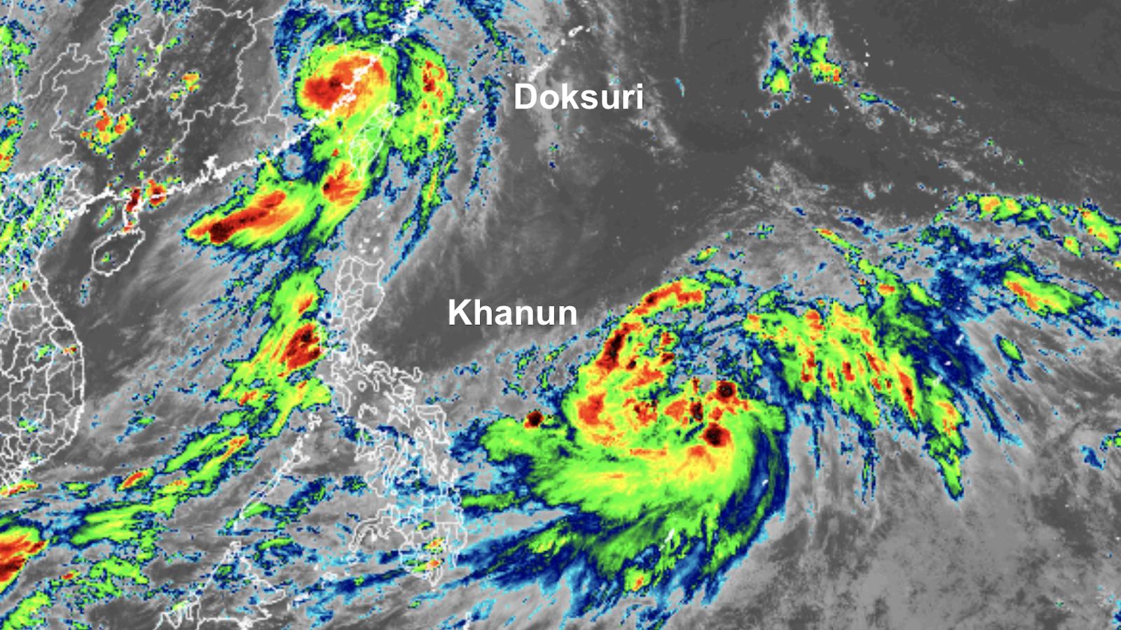
Typhoon Doksuri crashed onto the east-central coast of China at 9:55 a.m. local time Friday, July 28 (9:55 p.m. EDT Thursday). According to the Joint Typhoon Warning Center, Doksuri’s top one-minute winds just before landfall were 95 knots (110 mph), near the top end of the category 2 range for hurricanes. The typhoon made landfall in the Jinjiang area, toward the eastern end of the heavily populated Xiamen-Quanzhou area.
A rightward/northward swing in Doksuri’s track before landfall ended up putting most of the area on the typhoon’s weaker left hand side, reducing the impact on the overall megalopolis. More than 400,000 people had evacuated along and near the coast.
Along Doksuri’s path, torrential rains and associated flooding, landslides, and downed trees led to at least 13 deaths in the Philippines, the Associated Press reported. In addition, 26 people were killed when a ferry when a passenger boat capsized in gusty winds and rough seas east of Manila as Doksuri was passing well to the north. In Taiwan, according to CNN, officials reported one death and 68 injuries from torrential rains and flooding north of Doksuri’s path.
Next up: Khanun
On the heels of Doksuri, another typhoon is on track to develop and move toward the China coast, perhaps affecting the Ryukyu Islands of Japan en route. As of 11 a.m. EDT Friday, Tropical Storm Khanun was slowly organizing in the Northwest Pacific a few hundred miles northeast of the Philippines. Khanun’s top sustained winds were 40 mph, according to the Joint Typhoon Warning Center.
Rather than recurving toward the north and northeast, as so many typhoons do, Khanun is expected to take a long, loopy turn toward the northwest and west, arcing between an upper low in the subtropics and strong upper-level ridging to its north. This unusual but fairly straightforward track would keep Khanun over warm waters of around 29 degrees Celsius (84 degrees Fahrenheit) for most of its journey toward the Ryukyu Islands and eventually China. Upper-level wind shear is currently on the high side, around 15-20 knots, pushing a wedge of dry air into Khanun and shoving most of the showers and thunderstorms southward. The wind shear is predicted to slacken below 10 knots from this weekend into early next week. Together with a moist atmosphere downstream, these factors should allow Khanun to gradually strengthen; rapid intensification is not guaranteed, though, because the projected north-to-west arcing track will put the storm over waters with relatively low deep-ocean heat content.
Members of the European model ensemble are in close agreement on a landfall somewhere between Xiamen and Shanghai around midweek, while some members of the GFS ensemble show a recurvature northward around the time Khanun would be approaching China, a track that could lead to eventual impacts in Korea. The new HAFS-A high-resolution model indicates that Khanun could approach the China coast as a category 1 or 2 typhoon, while the Joint Typhoon Warning Center is predicting a possible category 3 landfall near Shanghai.

Atlantic mostly quiet for the time being
Land areas should remain free of serious threats from Atlantic tropical cyclones into at least early next week. A tropical wave located midway between the Cabo Verde Islands and the Lesser Antilles will continue rolling west-northwest across the Atlantic during the next several days. By Monday, July 31, the wave is expected to be several hundred miles northeast of the Leeward Islands, and there is some support for development around that time from a number of members of the GFS and European model ensembles. However, it now appears any such system would most likely recurve over the open Atlantic. Bermuda is likely to be the only land area threatened by the system next week. In its 2 p.m. EDT Friday Tropical Weather Outlook, the National Hurricane Center gave the disturbance two-day and seven-day odds of development of 20% and 60%, respectively.
A weak but fairly organized disturbance pushed into coastal Georgia on Friday morning with a swirl of scattered showers and thunderstorms, fortunately without having had time to organize into a tropical cyclone. Another tropical wave will be coming onshore into Nicaragua and Honduras by Friday night, with only a 10% chance of development while still offshore.
Jeff Masters contributed to this post. Website visitors can comment on “Eye on the Storm” posts (see comments policy below). Sign up to receive notices of new postings here.
Source link