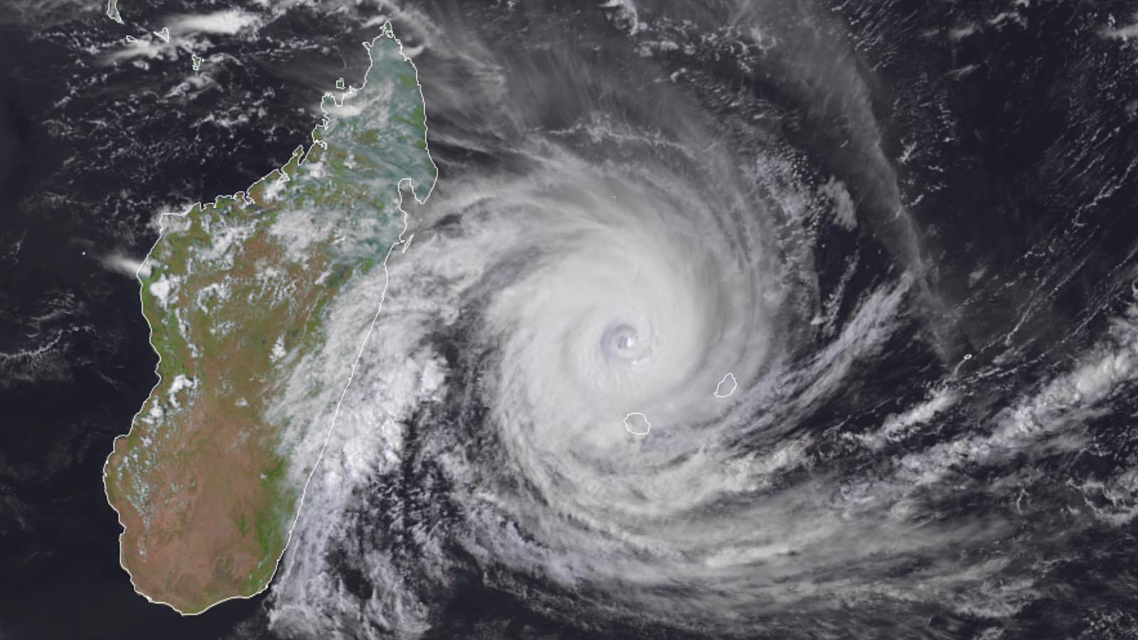
The island nation of Madagascar, already reeling from flooding rains from Tropical Storm Ana on January 22 and a devastating drought in southern parts of the nation, is bracing for the expected arrival of Tropical Cyclone Batsirai on Saturday.
At 10 a.m. EST Thursday, February 3, Batsirai was a category 4 storm with 130 mph winds, headed west-southwest at 5 mph, according to the Joint Typhoon Warning Center. Radar from La Réunion showed that Batsirai had completed an eyewall replacement cycle early Thursday, and the cyclone was not as organized as it was on Wednesday. High wind shear of about 20 knots was interfering with intensification, and the atmosphere was on the dry side, with a mid-level relative humidity of 55%. Sea surface temperatures were a warm 28 degrees Celsius (82°F).
The Joint Typhoon Warning Center and most of the top intensity models predict that Batsirai will continue tracking west-southwest and gradually weaken, making landfall in east-central Madagascar around 12Z (3 p.m. local time) Saturday, February 5, as a category 2 storm. The coast there is moderately populated, and damage from storm surge and wind is likely to be extensive. However, the biggest concern from Batsirai will be its widespread rains of 8-16” expected to affect a populated area. Batsari’s heavy rain area may end up just south of the most heavily populated city in the country, the capital of Antananarivo, but the nation’s third-largest city, Antsirabe (population 250,000) will likely get rains in excess of 10 inches. Unfortunately, Batsirai’s rains will mostly miss southern Madagascar, where a multiyear drought has 1.6 million people at high levels of acute food insecurity.
Batsirai’s rains will likely cause extensive flooding and major damage to the country, and the storm has the potential to be one of the top five most expensive disasters in Malagasy history. The damage potential is higher than for previous storms of similar intensity, because of the considerable deforestation Madagascar has experienced over the past 20 years: Madagascar lost 24% of its forest cover between 2000 and 2020, according to globalforestwatch.org. Madagascar is quite mountainous, and flood waters run off more quickly from deforested mountains, reach higher heights, and cause greater damage.


Madagascar already reeling from Tropical Storm Ana
Batsirai’s rains will be affecting a portion of Madagascar already suffering from the impact of Tropical Storm Ana, the first named storm of the Southwest Indian Ocean cyclone season. Ana crossed over Madagascar in January as a tropical depression, bringing floods that killed 48 people and left 71,000 people homeless. Ana also killed 18 people in Mozambique and 29 in Malawi, after making landfall in Mozambique as a tropical storm with 60 mph winds.
Madagascar tropical cyclone history
Major tropical cyclones have hit Madagascar an average of about once every three years since accurate satellite data began in 1997; there were eight such landfalls from 1997-2021. The strongest and deadliest tropical cyclone to hit the island in the satellite era was Tropical Cyclone Gafilo, which hit the northern end of Madagascar on March 7, 2004, as a category 4 storm with 150 mph winds. Galfilo dumped up to 20 inches of rain, and its winds and flooding rains killed 363 people and did $375 million in damage (2022 USD), making it the fourth-most expensive storm in Madagascar’s history. Before making landfall, Gafilo’s central pressure of 895 mb was the lowest of any tropical cyclone ever recorded in the South Indian Ocean.
Six other category 4 storms have hit the island:
Cyclone Enawo, March 7, 2017, 150 mph winds;
Cyclone Givanna, February 13, 2012, 130 mph winds;
Cyclone Hudah, April 2, 2000, 130 mph winds;
Cyclone Gretelle, January 24, 1997, 130 mph winds;
Cyclone Bonita, January 10, 1996, 130 mph winds; and
Cyclone Geralda, February 2, 1994, 130 mph winds.
In addition, a March 1927 cyclone that killed as many as 500 people may have been a Cat 4.
Madagascar’s most expensive tropical cyclone was Tropical Cyclone Emilie, which made landfall on the island’s east coast on February 2, 1977, as a minimal tropical storm with 40 mph winds. Emilie dumped torrential rains that caused $1.7 billion in damage (2022 USD).


Batsirai’s rains expected to miss Madagascar’s worst drought areas
Southern Madagascar has been facing a severe food security crisis brought about by drought, with the rainy seasons of both 2019/20 and 2020/21 bringing just 60% of normal rainfall. The lack of rain over the 24 months from July 2019 to June 2021 was estimated as a 1-in-135-year dry event, surpassed in severity only by the devastating drought of 1990-92. The drought has put over 1.6 million people at high levels of acute food insecurity.
Batsirai’s rains are predicted to mostly miss the most drought-ravaged portions of southern Madagascar, but will help with the less severe drought conditions over the remainder of the island.


Climate change not the main driver of Madagascar’s drought
Climate scientists authoring a December study with the World Weather Attribution group, “Factors other than climate change are the main drivers of recent food insecurity in Southern Madagascar,” found that “occurrence of poor rains as observed from July 2019 to June 2021 in Southern Madagascar has not significantly increased due to human-caused climate change.”
Even where precipitation has not changed, human-caused global warming has been found to make drought more intense in many parts of the world by increasing evaporation and drying out vegetation. However, the authors believe this is not the case for Madagascar. They cited Kew et al. (2021), who found that in arid and semi-arid regions in East Africa, climate change-induced increases in temperature do not appear to cause significant increases in the likelihood of witnessing exceptional soil moisture deficits (and thus more intense droughts that dry out vegetation and hurt crops).
The World Weather Attribution authors also summarized recent climate modeling research, which suggests that “future warming over the twenty-first century could lead to small-to-moderate increases in wet-season rainfall over southern Madagascar, while the latter half of the dry season (August-October) is projected to become drier and longer.”
South Indian Ocean tropical cyclone history
NOAA’s hurricane history database lists 18 tropical cyclones in the South Indian Ocean that have achieved category 5 strength since 1989. Since accurate satellite record keeping began in 1997, 14 category 5 storms have occurred in the South Indian Ocean—an average of approximately one Cat 5 every two years.
The strongest of these storms, Tropical Cyclone Fantala in 2016, peaked with maximum sustained winds of 180 mph and a central pressure of 907 mb pressure. Fantala did not make landfall, though its eyewall did affect the Farquhar Atoll while the storm was at category 5 strength. Fantala is also the all-time intensity record holder for the entire Indian Ocean, since it tops the record holder for the North Indian Ocean, Tropical Cyclone Fani of May 2019 (peak 1-minute winds of 175 mph). Note, though, that some consider Tropical Cyclone Monica of 2006 (180 mph winds) tied as the strongest Indian Ocean Basin storm on record. Definitions vary on the boundary of the Indian Ocean, though, and Monica reached peak strength north of Australia in the Arafura Sea, which is considered by several sources, including the CIA World Factbook, to be part of the western Pacific Ocean, not the Indian Ocean.
No South Indian Ocean tropical cyclone has ever been recorded to make landfall at category 5 strength. At least 17 have made landfall at category 4 strength: two in Mozambique, seven in Madagascar, and eight in western Australia.
The most recent Cat 5 in the basin was Faraji (160 mph winds, 925 mb central pressure) on February 8, 2021.
Bob Henson contributed to this post.
Website visitors can comment on “Eye on the Storm” posts. Comments are generally open for 30 days from date posted. Sign up to receive email announcements of new postings here. Twitter: @DrJeffMasters and @bhensonweather
Source link