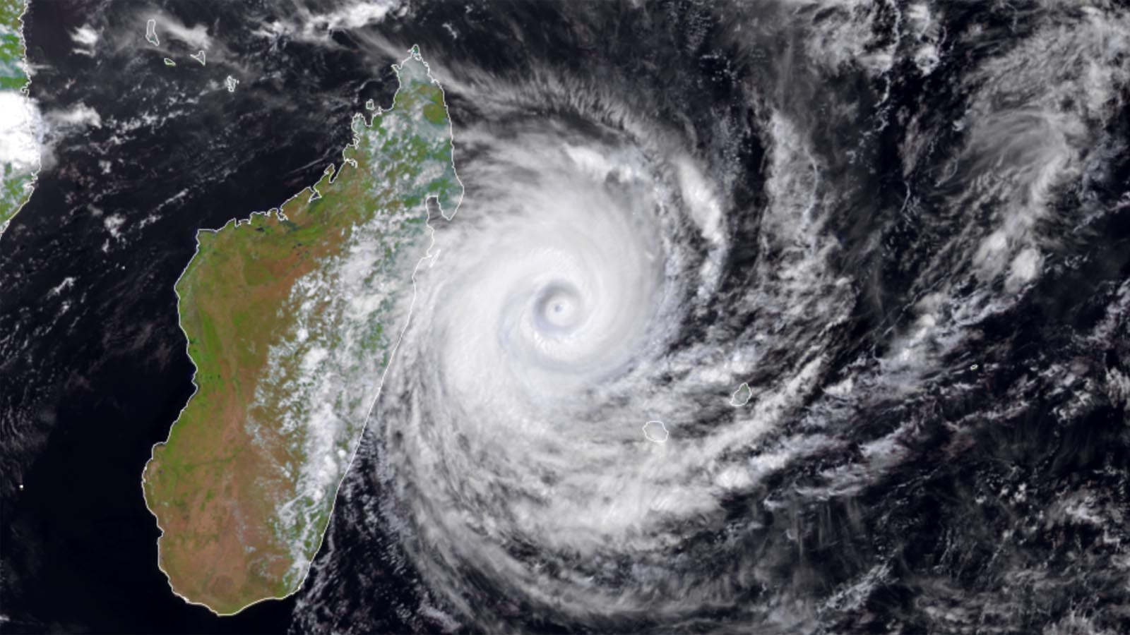
The island nation of Madagascar, already reeling from the impact of three previous tropical cyclones this year, plus a devastating drought in southern parts of the nation, is bracing for the expected arrival of Tropical Cyclone Emnati on Tuesday.
At 7 a.m. EST Monday, February 21, Emnati was a category 3 storm with 115 mph winds, headed west-southwest at 7 mph, according to the Joint Typhoon Warning Center. Emnati had weakened from its Sunday peak as a category 4 storm with 130 mph winds because of an eyewall replacement cycle, combined with the influence of cooler waters near the coast of Madagascar (stirred up by the passage of three other tropical cyclones over the past month). If Emnati can complete its eyewall replacement cycle, sea surface temperatures near 28 degrees Celsius (82°F) and low to moderate wind shear may allow the storm to maintain category 3 strength until landfall, as predicted by the Joint Typhoon Warning Center (JTWC).
JTWC and most of the top intensity models predict that Emnati will continue tracking west-southwest or southwest, making landfall in southeastern Madagascar late Tuesday or early Wednesday as a category 2 or 3 storm. This area is moderately populated, and damage from storm surge and wind is likely to be extensive. However, the biggest concern from Emnati will be its widespread rains of 4-8 inches, which will likely cause extensive flooding and major damage. The damage potential is higher than for past storms of similar intensity, because of the considerable deforestation Madagascar has experienced over the past 20 years: Madagascar lost 24% of its forest cover between 2000 and 2020, according to globalforestwatch.org. Madagascar is quite mountainous, and flood waters run off more quickly from deforested mountains, reach higher heights, and cause greater damage.
However, Emnati’s rains will affect a portion of the country experiencing a multiyear drought that has left 1.6 million people at high levels of acute food insecurity. Emnati’s rains have the potential to bring significant drought relief – though the flooding caused by the rains is likely to cause crop damage, as occurred when Tropical Cyclone Batsirai hit the island on February 5.


Madagascar’s very bad disaster year getting worse
Only 16 days ago, Madagascar endured a devastating landfall by Tropical Cyclone Batsirai, which made landfall on the island’s east central coast near on February 5 as a category 3 storm with 115 mph winds, according to the Joint Typhoon Warning Center. Batsirai killed 121 people, damaged or destroyed over 20,00 homes, and left 21,000 people homeless in Madagascar; over eight inches of rain fell near the landfall region. Fortunately, Batsirai also brought one to four inches of rain to the drought-stricken southern portion of Madagascar.


Before Batsirai, Madagascar was already suffering from the impact of Tropical Storm Ana, the first named storm of the Southwest Indian Ocean cyclone season. Ana crossed over Madagascar in January as a tropical depression with 35 mph winds, bringing floods that killed 48 people and left 71,000 people homeless. Ana also killed 18 people in Mozambique and 29 in Malawi, after making landfall in Mozambique as a tropical storm with 60 mph winds.
And just last week, Tropical Storm Dumako made landfall in northeastern Madagascar, on February 15. Though Dumako was a small storm, flooding from its heavy rains killed six, destroyed 113 houses, and left 3,000 people homeless.
The record for most tropical cyclones to hit Madagascar in one year occurred in 1975, when five named storms and three tropical depressions hit the island.
Madagascar tropical cyclone history
Major tropical cyclones have hit Madagascar an average of about once every three years since full satellite coverage of the region began in 1998; there have been nine such landfalls from 1997-2022. The strongest and deadliest tropical cyclone to hit the island in the satellite era was Tropical Cyclone Gafilo, which hit the northern end of Madagascar on March 7, 2004, as a category 4 storm with 150 mph winds. Gafilo dumped up to 20 inches of rain, and its winds and flooding rains killed 363 people and did $375 million in damage (2022 USD), making it the fourth-most expensive storm in Madagascar’s history. Before making landfall, Gafilo’s central pressure of 895 mb was the lowest of any tropical cyclone ever recorded in the South Indian Ocean.
Six other category 4 storms have hit the island:
Cyclone Enawo, March 7, 2017, 150 mph winds;
Cyclone Givanna, February 13, 2012, 130 mph winds;
Cyclone Hudah, April 2, 2000, 130 mph winds;
Cyclone Gretelle, January 24, 1997, 130 mph winds;
Cyclone Bonita, January 10, 1996, 130 mph winds; and
Cyclone Geralda, February 2, 1994, 130 mph winds.
In addition, a March 1927 cyclone that killed as many as 500 people may have been a Cat 4.
Madagascar’s most expensive tropical cyclone was Tropical Cyclone Emilie, which made landfall on the island’s east coast on February 2, 1977, as a minimal tropical storm with 40 mph winds. Emilie dumped torrential rains that caused $1.7 billion in damage (2022 USD).
As noted in the Tweet above by hurricane scientist Kieran Bhatia, the ability to detect a climate change signal in tropical cyclones affecting Madagascar is being hampered because full satellite coverage of the region was not available until 1998.


Climate change not the main driver of Madagascar’s drought
Climate scientists authoring a December study with the World Weather Attribution group, “Factors other than climate change are the main drivers of recent food insecurity in Southern Madagascar,” found that “occurrence of poor rains as observed from July 2019 to June 2021 in Southern Madagascar has not significantly increased due to human-caused climate change.”
Even where precipitation has not changed, human-caused global warming has been found to make drought more intense in many parts of the world by increasing evaporation and drying out vegetation. However, the authors believe this is not the case for Madagascar. They cited Kew et al. (2021), who found that in arid and semi-arid regions in East Africa, climate change-induced increases in temperature do not appear to cause significant increases in the likelihood of witnessing exceptional soil moisture deficits (and thus more intense droughts that dry out vegetation and hurt crops).
The World Weather Attribution authors also summarized recent climate modeling research, which suggests that “future warming over the twenty-first century could lead to small-to-moderate increases in wet-season rainfall over southern Madagascar, while the latter half of the dry season (August-October) is projected to become drier and longer.”
Bob Henson contributed to this post.
Website visitors can comment on “Eye on the Storm” posts. Comments are generally open for 30 days from date posted. Sign up to receive email announcements of new postings here. Twitter: @DrJeffMasters and @bhensonweather
Source link