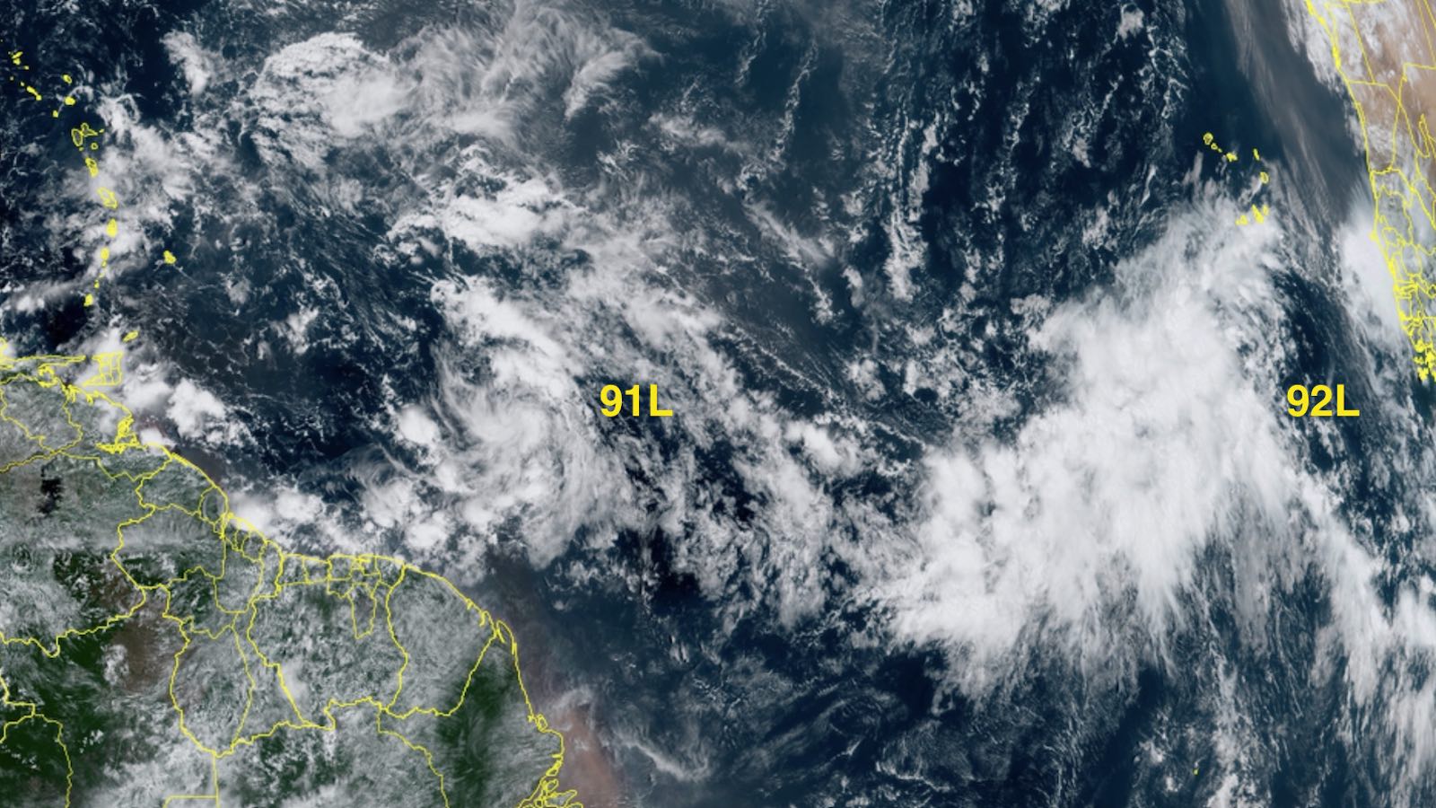
Just days after Hurricane Ian tore across Florida, a new system several hundred miles east of the Windward Islands may gradually develop into a named storm that could eventually threaten parts of the Caribbean. This tropical wave was designated Invest 91L on Sunday and was headed west at 15-20 mph. The system has favorable conditions for development, with warm waters near 30 degrees Celsius (86°F), light wind shear of 5 – 10 knots, and a reasonably moist atmosphere (a mid-level relative humidity of 65%).
The limited amount of heavy thunderstorm activity seen with 91L on satellite imagery Monday afternoon suggests that dry air to its north and west was hampering development. The wave had become more organized than on Sunday, though, and it had plenty of rotation.
91L will pass through the Lesser Antilles Islands on Wednesday night and enter the eastern Caribbean on Thursday, bringing gusty winds and heavy rain showers to the islands. Monday morning runs of the GFS and European ensemble model forecasts gave the wave modest support for development by late this week, when it is expected to be in the central Caribbean. A narrow ridge of high pressure to the north of the wave should keep it confined to the Caribbean, with a potential long-range threat to Central America next week. In its Tropical Weather Outlook issued at 2 p.m. EDT Monday, the National Hurricane Center (NHC) gave 91L 2-day and 5-day odds of development of 20% and 30%, respectively. A hurricane hunter aircraft is scheduled to investigate 91L on Tuesday, if necessary.


Tropical development also possible in the eastern Atlantic by midweek
Another disturbance, this one in the far eastern Atlantic near latitude 25 degrees west, was designated Invest 92L on Monday. Showers and thunderstorms have expanded around this tropical wave, and the upper-level outflow has increased, with outflow jets running both north and south from it. Through Tuesday, 92L will benefit from light wind shear (less than 10 knots), a moist mid-level atmosphere (relative humidity 60-65%), and warm waters between 28 and 29 degrees Celsius (82-84 degrees Fahrenheit). By Wednesday, wind shear will increase dramatically as a weak, slow-moving upper low in the central Atlantic pulls 92L northward, likely capping its strength. If 92L happens to survive a few days beyond that, it will eventually get swept eastward by strong upper-level flow from North America into the Atlantic, so it is not expected to threaten any land areas.
At 2 p.m. EDT Monday, NHC gave 92L 2-day and 5-day odds of development of 60% and 70%, respectively. The next two names on the Atlantic list are Julia and Karl.


Orlene makes landfall southeast of Mazatlan, Mexico
After a dramatic burst of rapid intensification on Saturday night that briefly took it to category 4 strength, Hurricane Orlene made landfall on Monday morning in a much-weakened state. Orlene reached the Pacific coast of Mexico around 9:45 a.m. EDT about 45 miles southeast of Mazatlan, near the border between the states of Nayarit and Sinaloa, with top sustained winds of 85 mph (category 1 strength).
Orlene struck a sparsely populated stretch of coastline as a small hurricane: winds of tropical storm strength extended out fewer than 100 miles in any direction, and hurricane-force winds fewer than 20 miles. These factors should keep wind impacts limited, and the heaviest rainfall (3 to 6 inches, perhaps reaching 10 inches in isolated spots) will be mainly restricted to areas near the storm center. Orlene will weaken quickly in the rugged terrain, becoming a remnant low by Tuesday.


Flooding associated with Ian’s remnants continues across Mid-Atlantic
Coastal flooding exacerbated by the remnants of Hurricane Ian continued to plague the Mid-Atlantic coast on Monday. Beneath an upper-level low parked over the region on Monday, an area of surface low pressure offshore associated with Ian’s remnants has teamed up with strong high pressure over New England. As a result, strong north-northeasterly winds continue to flow into the coast from New York to North Carolina. Temperatures in the low 50s and gusty north winds led to a distinctly non-tropical feeling along the coast on Monday.
Forecasts for the peak water values for the midday high tide on Monday have been eased downward somewhat, but at some places the worst coastal flooding in 5 to 10 years or more can be expected. Moderate to major flooding will continue at some locations over high tides through Tuesday and even Wednesday.
Cleanup and damage assessment is continuing this week in the wake of Ian’s rampage across Florida. The death toll from Ian in the United States had reached 85 by early Monday, according to Reuters, including 81 fatalities in Florida and four in North Carolina. Three deaths were reported from Ian in Cuba. The latest estimate of U.S. insured damage from risk modeling firm Verisk was between $42 and $57 billion on Monday. Since total damage typically ends up a factor of two higher than insured damage, the total price tag for Ian’s rampage might be in the $90 – 110 billion range, which would make it one of the five most expensive inflation-adjusted weather disasters in U.S. history (see our post from September 30). The other four are all hurricanes that occurred with the last 20 years: Katrina, Harvey, Maria, and Sandy.
Website visitors can comment on “Eye on the Storm” posts (see comments policy below). Sign up to receive notices of new postings here.
Source link